
Cargolate été 2021 étape 5
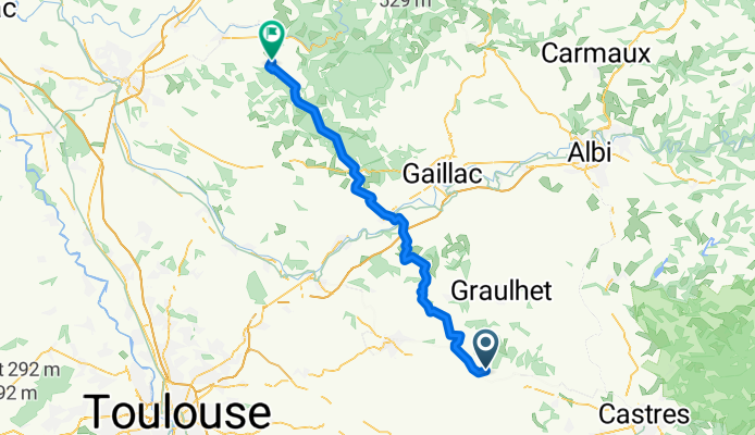
A cycling route starting in Saint-Paul-Cap-de-Joux, Occitanie, France.
Overview
About this route
18/08
67.9km
+750d+
total 290.2km
- -:--
- Duration
- 67.9 km
- Distance
- 560 m
- Ascent
- 575 m
- Descent
- ---
- Avg. speed
- 274 m
- Max. altitude
Route quality
Waytypes & surfaces along the route
Waytypes
Road
34.6 km
(51 %)
Quiet road
26.5 km
(39 %)
Surfaces
Paved
17.6 km
(26 %)
Asphalt
17.6 km
(26 %)
Undefined
50.2 km
(74 %)
Route highlights
Points of interest along the route
Point of interest after 0 km
BIVOUAC 1 14 aout 30km
Point of interest after 0 km
BIVOUAC 3 (159km) 16 aout +70km
Point of interest after 0 km
BIVOUAC 4 17 aout 226km +70km
Point of interest after 0 km
BIVOUAC 2 +61km 15 aout 91 km
Point of interest after 0 km
BIVOUAC 4 (+219km) +60
Point of interest after 0.1 km
BIVOUAC 4 camping bis
Point of interest after 67.8 km
BIVOUAC 6
Point of interest after 67.8 km
PISCINE (418km) 20 aout 72km
Point of interest after 67.9 km
BIVOUAC5 290km
Continue with Bikemap
Use, edit, or download this cycling route
You would like to ride Cargolate été 2021 étape 5 or customize it for your own trip? Here is what you can do with this Bikemap route:
Free features
- Save this route as favorite or in collections
- Copy & plan your own version of this route
- Sync your route with Garmin or Wahoo
Premium features
Free trial for 3 days, or one-time payment. More about Bikemap Premium.
- Navigate this route on iOS & Android
- Export a GPX / KML file of this route
- Create your custom printout (try it for free)
- Download this route for offline navigation
Discover more Premium features.
Get Bikemap PremiumFrom our community
Other popular routes starting in Saint-Paul-Cap-de-Joux
 jour 2.0
- Distance
- 71.8 km
- Ascent
- 303 m
- Descent
- 276 m
- Location
- Saint-Paul-Cap-de-Joux, Occitanie, France
 Le Cun, Puylaurens to Le Cun, Puylaurens
- Distance
- 15.4 km
- Ascent
- 51 m
- Descent
- 21 m
- Location
- Saint-Paul-Cap-de-Joux, Occitanie, France
 Easy ride in Magrin
- Distance
- 13.1 km
- Ascent
- 401 m
- Descent
- 398 m
- Location
- Saint-Paul-Cap-de-Joux, Occitanie, France
 Cargolate été 2021 étape 5
- Distance
- 67.9 km
- Ascent
- 560 m
- Descent
- 575 m
- Location
- Saint-Paul-Cap-de-Joux, Occitanie, France
 Restful route
- Distance
- 18.7 km
- Ascent
- 384 m
- Descent
- 354 m
- Location
- Saint-Paul-Cap-de-Joux, Occitanie, France
 Le Cun, Puylaurens to Le Cun, Puylaurens
- Distance
- 28.6 km
- Ascent
- 60 m
- Descent
- 126 m
- Location
- Saint-Paul-Cap-de-Joux, Occitanie, France
 De 878 La Baudonie, Serviès à Avenue de l'Autan, Serviès
- Distance
- 3.6 km
- Ascent
- 53 m
- Descent
- 31 m
- Location
- Saint-Paul-Cap-de-Joux, Occitanie, France
 De 196 Hameau La Baudonié, Serviès à 196 Hameau La Baudonié, Serviès
- Distance
- 6 km
- Ascent
- 38 m
- Descent
- 34 m
- Location
- Saint-Paul-Cap-de-Joux, Occitanie, France
Open it in the app