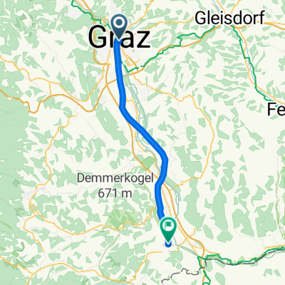
flach-kurz-schnell- ca. 30 km
A cycling route starting in Graz, Styria, Austria.
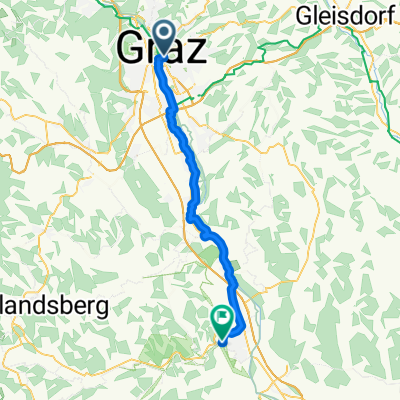
Overview
About this route
The route can be extended at will! Towards Unterpremstätten, Weststeiermark DL or VO, or further south.
From Augarten, follow the cycle path southwards, at the Puntigamer Bridge head towards Mitterstrasse, cross the railway and continue right along the track heading south, ideal for fast riding. After the airport, turn right, pass behind the airfield, practically circling it. Follow the cycle path, a short stretch on the federal road, passing the Schwarzlsee lake, take the roundabout to the right, parallel to the motorway, join Mitterstrasse, continue to the intersection with Triesterstrasse, From there close the loop, back to Augarten.
- -:--
- Duration
- 27.8 km
- Distance
- 43 m
- Ascent
- 46 m
- Descent
- ---
- Avg. speed
- ---
- Max. altitude
Route quality
Waytypes & surfaces along the route
Waytypes
Quiet road
12.8 km
(46 %)
Cycleway
10 km
(36 %)
Surfaces
Paved
26.2 km
(94 %)
Unpaved
0.6 km
(2 %)
Asphalt
24.5 km
(88 %)
Paved (undefined)
1.7 km
(6 %)
Continue with Bikemap
Use, edit, or download this cycling route
You would like to ride flach-kurz-schnell- ca. 30 km or customize it for your own trip? Here is what you can do with this Bikemap route:
Free features
- Save this route as favorite or in collections
- Copy & plan your own version of this route
- Sync your route with Garmin or Wahoo
Premium features
Free trial for 3 days, or one-time payment. More about Bikemap Premium.
- Navigate this route on iOS & Android
- Export a GPX / KML file of this route
- Create your custom printout (try it for free)
- Download this route for offline navigation
Discover more Premium features.
Get Bikemap PremiumFrom our community
Other popular routes starting in Graz
- Lassnitzhöhe short training route...
- Distance
- 28.5 km
- Ascent
- 330 m
- Descent
- 328 m
- Location
- Graz, Styria, Austria
- Graz - St. Pankrazen - Graz
- Distance
- 70.7 km
- Ascent
- 643 m
- Descent
- 643 m
- Location
- Graz, Styria, Austria
- Graz - Kirchbach - Leibnitz - Dietersdorf - Graz
- Distance
- 93.5 km
- Ascent
- 667 m
- Descent
- 675 m
- Location
- Graz, Styria, Austria
- Schöne ruhige Rennradrunde
- Distance
- 58.6 km
- Ascent
- 547 m
- Descent
- 544 m
- Location
- Graz, Styria, Austria
- Graz After-Work-Tour #1
- Distance
- 26.9 km
- Ascent
- 297 m
- Descent
- 294 m
- Location
- Graz, Styria, Austria
- Plabutschrunde mit Ruine Gösting und Thalersee
- Distance
- 30.8 km
- Ascent
- 642 m
- Descent
- 642 m
- Location
- Graz, Styria, Austria
- Platte und Hauenstein
- Distance
- 37.9 km
- Ascent
- 860 m
- Descent
- 860 m
- Location
- Graz, Styria, Austria
- stPETER UND DER WOLFsgraben CLONED FROM ROUTE 1034877
- Distance
- 28.6 km
- Ascent
- 547 m
- Descent
- 547 m
- Location
- Graz, Styria, Austria
Open it in the app