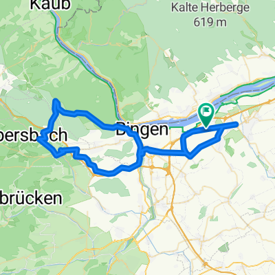
045a: Ingelheim - Flonheim - Weinheim - Nack - Wöllstein - Col de Deponie - Ingelheim

A cycling route starting in Gau-Algesheim, Rhineland-Palatinate, Germany.
OverviewAbout this route

Start & finish location: Gate 1

Ingelheim - Gau-Algesheim - Appenheim - Nieder-Hilbersheim - Ober-Hilbersheim - Wolfsheim - Gau-Weinheim - Wallertheim - Schimsheim - Armsheim - Flonheim - Bornheim - Lonsheim - Heimersheim - Weinheim - Offenheim - Erbes-Büdesheim - Nack - Wendelsheim - Eckelsheim - Wöllstein - Badenheim - Sprendlingen - Col de Deponie - Ober-Hilbersheim - Appenheim - Gau-Algesheim - Ingelheim

Translated, show original (German)
-:--
Duration
84.8 km
Distance
635 m
Ascent
635 m
Descent
---
Avg. speed
---
Max. altitude
Route qualityWaytypes & surfaces along the route
Waytypes
  • Road

    24.6 km29 %
  • Track

    10.2 km12 %
  • Quiet road

    4.2 km5 %
Surfaces

Paved

77.2 km(91 %)

Unpaved

2.5 km(3 %)
  • Asphalt

    73.8 km87 %
  • Paved (undefined)

    2.5 km3 %
  • Ground

    1.7 km2 %
Continue with BikemapUse, edit, or download this cycling route
You would like to ride 045a: Ingelheim - Flonheim - Weinheim - Nack - Wöllstein - Col de Deponie - Ingelheim or customize it for your own trip? Here is what you can do with this Bikemap route:
Free features
Premium features

Free trial for 3 days, or one-time payment. More about Bikemap Premium.

  • Navigate this route on iOS & Android
  • Export a GPX / KML file of this route
  • Create your custom printout (try it for free)
  • Download this route for offline navigation

Discover more Premium features.

Get Bikemap Premium
From our communityOther popular routes starting in Gau-Algesheim

Open it in the app