

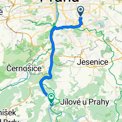
Kocaba podruhe
A cycling route starting in Vysehrad, Prague, Czechia.
Overview
About this route
Kocaba a little differently. Compared to the original route, the road to Vrane is easier and avoids the hill from Davle - but this is offset by a not very pleasant road along the main route to Stechovice. From Mnisku pod Brdy, you do not go over the ridge, but towards Ritka, which again eliminates one hill.
- -:--
- Duration
- 95.6 km
- Distance
- 595 m
- Ascent
- 543 m
- Descent
- ---
- Avg. speed
- ---
- Max. altitude

Continue with Bikemap
Use, edit, or download this cycling route
You would like to ride Kocaba podruhe or customize it for your own trip? Here is what you can do with this Bikemap route:
Free features
- Save this route as favorite or in collections
- Copy & plan your own version of this route
- Split it into stages to create a multi-day tour
- Sync your route with Garmin or Wahoo
Premium features
Free trial for 3 days, or one-time payment. More about Bikemap Premium.
- Navigate this route on iOS & Android
- Export a GPX / KML file of this route
- Create your custom printout (try it for free)
- Download this route for offline navigation
Discover more Premium features.
Get Bikemap PremiumFrom our community
Other popular routes starting in Vysehrad
 Tocna (24.4.09) - lavina, apendix, stekajici pes
- Distance
- 55.5 km
- Ascent
- 307 m
- Descent
- 324 m
- Location
- Vysehrad, Prague, Czechia
 Slapy trip
- Distance
- 84.9 km
- Ascent
- 847 m
- Descent
- 687 m
- Location
- Vysehrad, Prague, Czechia
 Ze servisu na Spořilově
- Distance
- 52.4 km
- Ascent
- 498 m
- Descent
- 561 m
- Location
- Vysehrad, Prague, Czechia
 A little experimenting
- Distance
- 538.4 km
- Ascent
- 1,854 m
- Descent
- 1,854 m
- Location
- Vysehrad, Prague, Czechia
 Podolská do U Topíren
- Distance
- 10.7 km
- Ascent
- 100 m
- Descent
- 143 m
- Location
- Vysehrad, Prague, Czechia
 Sídliště, Davle do Podle náhonu, Praha 4
- Distance
- 28.4 km
- Ascent
- 437 m
- Descent
- 407 m
- Location
- Vysehrad, Prague, Czechia
 Kocaba podruhe
- Distance
- 95.6 km
- Ascent
- 595 m
- Descent
- 543 m
- Location
- Vysehrad, Prague, Czechia
 Velká podzimní cyklojízda 2011
- Distance
- 15.3 km
- Ascent
- 99 m
- Descent
- 129 m
- Location
- Vysehrad, Prague, Czechia
Open it in the app