

Tagesausflug Tschechien
A cycling route starting in Ottenthal, Lower Austria, Austria.
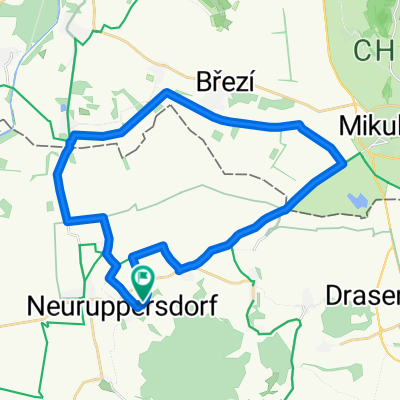
Overview
About this route
- -:--
- Duration
- 57.9 km
- Distance
- 144 m
- Ascent
- 150 m
- Descent
- ---
- Avg. speed
- 227 m
- Max. altitude

Route quality
Waytypes & surfaces along the route
Waytypes
Track
23.8 km
(41 %)
Road
17.4 km
(30 %)
Surfaces
Paved
34.6 km
(60 %)
Unpaved
11 km
(19 %)
Asphalt
33.4 km
(58 %)
Gravel
7.8 km
(13 %)
Continue with Bikemap
Use, edit, or download this cycling route
You would like to ride Tagesausflug Tschechien or customize it for your own trip? Here is what you can do with this Bikemap route:
Free features
- Save this route as favorite or in collections
- Copy & plan your own version of this route
- Sync your route with Garmin or Wahoo
Premium features
Free trial for 3 days, or one-time payment. More about Bikemap Premium.
- Navigate this route on iOS & Android
- Export a GPX / KML file of this route
- Create your custom printout (try it for free)
- Download this route for offline navigation
Discover more Premium features.
Get Bikemap PremiumFrom our community
Other popular routes starting in Ottenthal
 Mikulov-Wiedeń
- Distance
- 130.1 km
- Ascent
- 361 m
- Descent
- 399 m
- Location
- Ottenthal, Lower Austria, Austria
 Galgenberg-Ottenthal
- Distance
- 6.9 km
- Ascent
- 83 m
- Descent
- 62 m
- Location
- Ottenthal, Lower Austria, Austria
 Neuruppersdorf nach Neuruppersdorf
- Distance
- 29.1 km
- Ascent
- 220 m
- Descent
- 233 m
- Location
- Ottenthal, Lower Austria, Austria
 Pálava Radtour
- Distance
- 67.6 km
- Ascent
- 279 m
- Descent
- 320 m
- Location
- Ottenthal, Lower Austria, Austria
 Falkensteinský okruh
- Distance
- 23.4 km
- Ascent
- 300 m
- Descent
- 300 m
- Location
- Ottenthal, Lower Austria, Austria
 Neuruppersdorf 3, Neuruppersdorf to Pasohlávky
- Distance
- 23.3 km
- Ascent
- 90 m
- Descent
- 138 m
- Location
- Ottenthal, Lower Austria, Austria
 Galgenberg-Mikulov
- Distance
- 11.7 km
- Ascent
- 54 m
- Descent
- 63 m
- Location
- Ottenthal, Lower Austria, Austria
 Tagesausflug Tschechien
- Distance
- 57.9 km
- Ascent
- 144 m
- Descent
- 150 m
- Location
- Ottenthal, Lower Austria, Austria
Open it in the app