
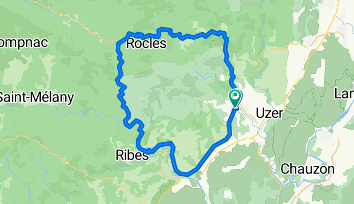
Salindré - Rosière
A cycling route starting in Largentière, Auvergne-Rhône-Alpes, France.
Overview
About this route
- -:--
- Duration
- 40 km
- Distance
- 403 m
- Ascent
- 406 m
- Descent
- ---
- Avg. speed
- 481 m
- Max. altitude
Route quality
Waytypes & surfaces along the route
Waytypes
Busy road
22.3 km
(56 %)
Road
14.1 km
(35 %)
Surfaces
Paved
18.7 km
(47 %)
Asphalt
18.7 km
(47 %)
Undefined
21.3 km
(53 %)
Continue with Bikemap
Use, edit, or download this cycling route
You would like to ride Salindré - Rosière or customize it for your own trip? Here is what you can do with this Bikemap route:
Free features
- Save this route as favorite or in collections
- Copy & plan your own version of this route
- Sync your route with Garmin or Wahoo
Premium features
Free trial for 3 days, or one-time payment. More about Bikemap Premium.
- Navigate this route on iOS & Android
- Export a GPX / KML file of this route
- Create your custom printout (try it for free)
- Download this route for offline navigation
Discover more Premium features.
Get Bikemap PremiumFrom our community
Other popular routes starting in Largentière
 Hinweg Ruoms
- Distance
- 17.5 km
- Ascent
- 248 m
- Descent
- 462 m
- Location
- Largentière, Auvergne-Rhône-Alpes, France
 Rondje vanuit L'Argentiere
- Distance
- 81.3 km
- Ascent
- 1,902 m
- Descent
- 1,923 m
- Location
- Largentière, Auvergne-Rhône-Alpes, France
 Halbe Tour am Col de Meyrand
- Distance
- 28.1 km
- Ascent
- 921 m
- Descent
- 916 m
- Location
- Largentière, Auvergne-Rhône-Alpes, France
 2016 Ride Day 109 - Largentière to Villefort
- Distance
- 47 km
- Ascent
- 863 m
- Descent
- 386 m
- Location
- Largentière, Auvergne-Rhône-Alpes, France
 La Landeà vélo
- Distance
- 35.6 km
- Ascent
- 502 m
- Descent
- 502 m
- Location
- Largentière, Auvergne-Rhône-Alpes, France
 Largentière-Pässefahrt
- Distance
- 84.8 km
- Ascent
- 3,418 m
- Descent
- 3,112 m
- Location
- Largentière, Auvergne-Rhône-Alpes, France
 Col de Meyrand
- Distance
- 22.2 km
- Ascent
- 1,180 m
- Descent
- 180 m
- Location
- Largentière, Auvergne-Rhône-Alpes, France
 Vogüe 80Km 600m
- Distance
- 80.9 km
- Ascent
- 414 m
- Descent
- 414 m
- Location
- Largentière, Auvergne-Rhône-Alpes, France
Open it in the app