

BRUGUERA+OGASSA
A cycling route starting in Sant Joan les Fonts, Catalonia, Spain.
Overview
About this route
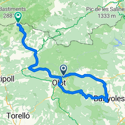
OLOT-RIPOLL-BRUGUERA-OGASSA-OLOT
- -:--
- Duration
- 97.5 km
- Distance
- 1,983 m
- Ascent
- 1,983 m
- Descent
- ---
- Avg. speed
- 1,637 m
- Max. altitude

Route quality
Waytypes & surfaces along the route
Waytypes
Road
21.5 km
(22 %)
Track
15.6 km
(16 %)
Surfaces
Paved
41 km
(42 %)
Asphalt
24.4 km
(25 %)
Concrete
15.6 km
(16 %)
Continue with Bikemap
Use, edit, or download this cycling route
You would like to ride BRUGUERA+OGASSA or customize it for your own trip? Here is what you can do with this Bikemap route:
Free features
- Save this route as favorite or in collections
- Copy & plan your own version of this route
- Split it into stages to create a multi-day tour
- Sync your route with Garmin or Wahoo
Premium features
Free trial for 3 days, or one-time payment. More about Bikemap Premium.
- Navigate this route on iOS & Android
- Export a GPX / KML file of this route
- Create your custom printout (try it for free)
- Download this route for offline navigation
Discover more Premium features.
Get Bikemap PremiumFrom our community
Other popular routes starting in Sant Joan les Fonts
 100% Tondo
- Distance
- 117.4 km
- Ascent
- 2,529 m
- Descent
- 719 m
- Location
- Sant Joan les Fonts, Catalonia, Spain
 trasa RP d8 dla chetnych
- Distance
- 77.8 km
- Ascent
- 1,886 m
- Descent
- 1,887 m
- Location
- Sant Joan les Fonts, Catalonia, Spain
 trasa RP d9 powoli konczymy
- Distance
- 68.7 km
- Ascent
- 547 m
- Descent
- 914 m
- Location
- Sant Joan les Fonts, Catalonia, Spain
 PETITA VOLTA a l'ALTA GARROTXA
- Distance
- 53.9 km
- Ascent
- 848 m
- Descent
- 848 m
- Location
- Sant Joan les Fonts, Catalonia, Spain
 BRUGUERA+OGASSA
- Distance
- 97.5 km
- Ascent
- 1,983 m
- Descent
- 1,983 m
- Location
- Sant Joan les Fonts, Catalonia, Spain
 st joan les fonts - cantina 3km to riudaura turning - la pinya - col d'uria - olot - st joan les fonts
- Distance
- 55.2 km
- Ascent
- 542 m
- Descent
- 540 m
- Location
- Sant Joan les Fonts, Catalonia, Spain
 Castellfollit - Oix - Beget - Setcases - Vallter 2000 - La Vall del Bac
- Distance
- 117.7 km
- Ascent
- 2,436 m
- Descent
- 2,442 m
- Location
- Sant Joan les Fonts, Catalonia, Spain
 VOLTA OLOT JULIOL
- Distance
- 135.5 km
- Ascent
- 2,819 m
- Descent
- 2,817 m
- Location
- Sant Joan les Fonts, Catalonia, Spain
Open it in the app