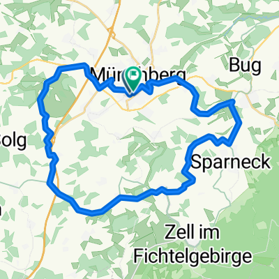
Rundtour ab Münchberg 1
A cycling route starting in Münchberg, Bavaria, Germany.
Overview
About this route
- -:--
- Duration
- 48.6 km
- Distance
- 429 m
- Ascent
- 430 m
- Descent
- ---
- Avg. speed
- ---
- Max. altitude
Route quality
Waytypes & surfaces along the route
Waytypes
Track
24.3 km
(50 %)
Quiet road
11.2 km
(23 %)
Surfaces
Paved
6.8 km
(14 %)
Unpaved
26.3 km
(54 %)
Gravel
11.7 km
(24 %)
Ground
9.2 km
(19 %)
Continue with Bikemap
Use, edit, or download this cycling route
You would like to ride Rundtour ab Münchberg 1 or customize it for your own trip? Here is what you can do with this Bikemap route:
Free features
- Save this route as favorite or in collections
- Copy & plan your own version of this route
- Sync your route with Garmin or Wahoo
Premium features
Free trial for 3 days, or one-time payment. More about Bikemap Premium.
- Navigate this route on iOS & Android
- Export a GPX / KML file of this route
- Create your custom printout (try it for free)
- Download this route for offline navigation
Discover more Premium features.
Get Bikemap PremiumFrom our community
Other popular routes starting in Münchberg
Münchberg Rundtour 3- Distance
- 41.2 km
- Ascent
- 376 m
- Descent
- 376 m
- Location
- Münchberg, Bavaria, Germany
F 12.1 Von Münchberg, Bhf. zur Saalequelle- Distance
- 11.1 km
- Ascent
- 242 m
- Descent
- 58 m
- Location
- Münchberg, Bavaria, Germany
Saaletour 2011 (Münchberg-Hohenthurm)- Distance
- 463.4 km
- Ascent
- 518 m
- Descent
- 950 m
- Location
- Münchberg, Bavaria, Germany
Amselweg, Münchberg nach Amselweg, Münchberg- Distance
- 44 km
- Ascent
- 640 m
- Descent
- 640 m
- Location
- Münchberg, Bavaria, Germany
Münchberg_Saalequelle_V1- Distance
- 13.1 km
- Ascent
- 278 m
- Descent
- 93 m
- Location
- Münchberg, Bavaria, Germany
26km um Münchberg herum- Distance
- 26.5 km
- Ascent
- 252 m
- Descent
- 250 m
- Location
- Münchberg, Bavaria, Germany
Saale 2011- Distance
- 504.3 km
- Ascent
- 563 m
- Descent
- 995 m
- Location
- Münchberg, Bavaria, Germany
Laubersreuth-Kulmbach- Distance
- 36.8 km
- Ascent
- 169 m
- Descent
- 446 m
- Location
- Münchberg, Bavaria, Germany
Open it in the app


