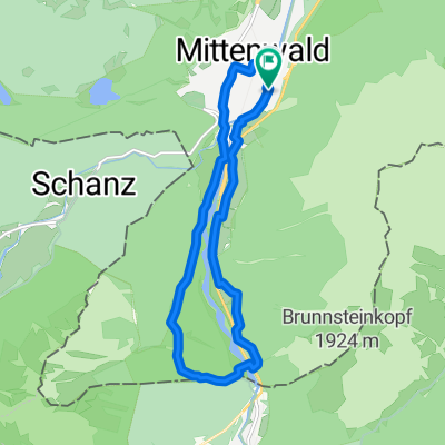
-> Ferein Alm -> Karwendelhaus
A cycling route starting in Mittenwald, Bavaria, Germany.
Overview
About this route
Von: Mittenwald
Über: Ferein Alm
Über: Hinterriß
Über: Rißbach
Über: Karwendelhaus
Über: Scharnitz
Nach: Mittenwald
- -:--
- Duration
- 67.7 km
- Distance
- 1,579 m
- Ascent
- 1,576 m
- Descent
- ---
- Avg. speed
- ---
- Avg. speed
Route quality
Waytypes & surfaces along the route
Waytypes
Undefined
67.7 km
(100 %)
Surfaces
Undefined
67.7 km
(100 %)
Route highlights
Points of interest along the route
Point of interest after 11.5 km
Ferein Alm
Point of interest after 41.3 km
Karwendelhaus
Continue with Bikemap
Use, edit, or download this cycling route
You would like to ride -> Ferein Alm -> Karwendelhaus or customize it for your own trip? Here is what you can do with this Bikemap route:
Free features
- Save this route as favorite or in collections
- Copy & plan your own version of this route
- Sync your route with Garmin or Wahoo
Premium features
Free trial for 3 days, or one-time payment. More about Bikemap Premium.
- Navigate this route on iOS & Android
- Export a GPX / KML file of this route
- Create your custom printout (try it for free)
- Download this route for offline navigation
Discover more Premium features.
Get Bikemap PremiumFrom our community
Other popular routes starting in Mittenwald
- Letzte Etappe Ulm-Gardasee-Ulm
- Distance
- 214.9 km
- Ascent
- 1,305 m
- Descent
- 1,666 m
- Location
- Mittenwald, Bavaria, Germany
- Unbenannte Route
- Distance
- 120.7 km
- Ascent
- 1,501 m
- Descent
- 1,727 m
- Location
- Mittenwald, Bavaria, Germany
- Lautersee-wettersteinalm-ellmau-lautersee
- Distance
- 22.9 km
- Ascent
- 558 m
- Descent
- 558 m
- Location
- Mittenwald, Bavaria, Germany
- Mittenwald - Eppzirlalm - Oberbrunnalm
- Distance
- 37.7 km
- Ascent
- 927 m
- Descent
- 926 m
- Location
- Mittenwald, Bavaria, Germany
- Karwendelrunde
- Distance
- 65 km
- Ascent
- 1,582 m
- Descent
- 1,572 m
- Location
- Mittenwald, Bavaria, Germany
- -> Ferein Alm -> Karwendelhaus
- Distance
- 67.7 km
- Ascent
- 1,579 m
- Descent
- 1,576 m
- Location
- Mittenwald, Bavaria, Germany
- Mittenwald_München
- Distance
- 115.5 km
- Ascent
- 214 m
- Descent
- 603 m
- Location
- Mittenwald, Bavaria, Germany
- Mittenwald-ElmauerAlm-HoherKranzberg-Arnspitzrunde
- Distance
- 70.3 km
- Ascent
- 1,142 m
- Descent
- 1,142 m
- Location
- Mittenwald, Bavaria, Germany