

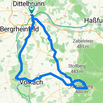
ETT 2022 6. Etappe 01.09.22
A cycling route starting in Schweinfurt, Bavaria, Germany.
Overview
About this route
Schweinfurt Hotel Mercue Maininsel 10 -12
Buchen Hotel Reichsadler and Hotel Prinz Carl
18.07. Rest stop changed in Unterwittighausen
Königstr. 17 behind town hall - street Am Pla
19.07. Town passage changed in Ochsenfurt
23.08. Break change Km 84 sports field Wiitighausen
- -:--
- Duration
- 134.9 km
- Distance
- 564 m
- Ascent
- 564 m
- Descent
- ---
- Avg. speed
- 301 m
- Max. altitude

Route quality
Waytypes & surfaces along the route
Waytypes
Road
39.1 km
(29 %)
Path
14.8 km
(11 %)
Surfaces
Paved
94.4 km
(70 %)
Asphalt
93.1 km
(69 %)
Paved (undefined)
1.3 km
(1 %)
Undefined
40.5 km
(30 %)
Continue with Bikemap
Use, edit, or download this cycling route
You would like to ride ETT 2022 6. Etappe 01.09.22 or customize it for your own trip? Here is what you can do with this Bikemap route:
Free features
- Save this route as favorite or in collections
- Copy & plan your own version of this route
- Split it into stages to create a multi-day tour
- Sync your route with Garmin or Wahoo
Premium features
Free trial for 3 days, or one-time payment. More about Bikemap Premium.
- Navigate this route on iOS & Android
- Export a GPX / KML file of this route
- Create your custom printout (try it for free)
- Download this route for offline navigation
Discover more Premium features.
Get Bikemap PremiumFrom our community
Other popular routes starting in Schweinfurt
 Schweinfurter Nordrunde
- Distance
- 36.9 km
- Ascent
- 498 m
- Descent
- 446 m
- Location
- Schweinfurt, Bavaria, Germany
 All Forest, All Good
- Distance
- 47.8 km
- Ascent
- 582 m
- Descent
- 582 m
- Location
- Schweinfurt, Bavaria, Germany
 Schweinfurt-Bad Neustadt-Höchheim
- Distance
- 67.6 km
- Ascent
- 352 m
- Descent
- 320 m
- Location
- Schweinfurt, Bavaria, Germany
 Schweinfurter Ostkreis
- Distance
- 72.7 km
- Ascent
- 749 m
- Descent
- 716 m
- Location
- Schweinfurt, Bavaria, Germany
 zur Ruine Aura, Wittelsbacher Turm und zurück
- Distance
- 54.7 km
- Ascent
- 707 m
- Descent
- 708 m
- Location
- Schweinfurt, Bavaria, Germany
 ETT 2022 6. Etappe 01.09.22
- Distance
- 134.9 km
- Ascent
- 564 m
- Descent
- 564 m
- Location
- Schweinfurt, Bavaria, Germany
 SW-VK-Baumwipfelpfad-GEO
- Distance
- 86.4 km
- Ascent
- 286 m
- Descent
- 286 m
- Location
- Schweinfurt, Bavaria, Germany
 Main Radweg Schweinfurt - Schwarzach
- Distance
- 43.1 km
- Ascent
- 82 m
- Descent
- 105 m
- Location
- Schweinfurt, Bavaria, Germany
Open it in the app