

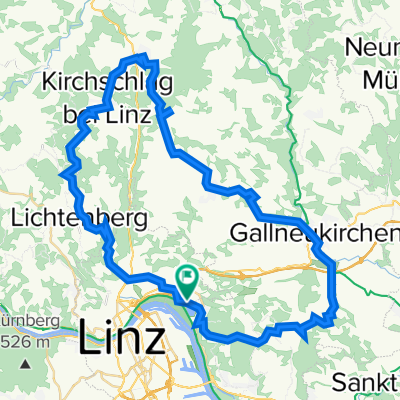
Linz - Mauthausen 26 km
A cycling route starting in Linz, Upper Austria, Austria.
Overview
About this route
Začátek v Linzi u Parkbadu, krátká projížďka městem, po EV6 podél Dunaje do Mauthausenu
- -:--
- Duration
- 26.2 km
- Distance
- 47 m
- Ascent
- 65 m
- Descent
- ---
- Avg. speed
- ---
- Max. altitude
Route quality
Waytypes & surfaces along the route
Waytypes
Cycleway
13.6 km
(52 %)
Road
3.7 km
(14 %)
Surfaces
Paved
23.1 km
(88 %)
Unpaved
1 km
(4 %)
Asphalt
22.8 km
(87 %)
Gravel
0.5 km
(2 %)
Continue with Bikemap
Use, edit, or download this cycling route
You would like to ride Linz - Mauthausen 26 km or customize it for your own trip? Here is what you can do with this Bikemap route:
Free features
- Save this route as favorite or in collections
- Copy & plan your own version of this route
- Sync your route with Garmin or Wahoo
Premium features
Free trial for 3 days, or one-time payment. More about Bikemap Premium.
- Navigate this route on iOS & Android
- Export a GPX / KML file of this route
- Create your custom printout (try it for free)
- Download this route for offline navigation
Discover more Premium features.
Get Bikemap PremiumFrom our community
Other popular routes starting in Linz
 Trail GIS – Bachlberg Variante01
- Distance
- 21.7 km
- Ascent
- 713 m
- Descent
- 850 m
- Location
- Linz, Upper Austria, Austria
 4.3.2023
- Distance
- 47.5 km
- Ascent
- 751 m
- Descent
- 749 m
- Location
- Linz, Upper Austria, Austria
 Lange Ausfahrt durch Linz
- Distance
- 45 km
- Ascent
- 634 m
- Descent
- 622 m
- Location
- Linz, Upper Austria, Austria
 Lichtenberg, Mirellental, Pfenningberg CLONED FROM ROUTE 38001
- Distance
- 54.3 km
- Ascent
- 1,090 m
- Descent
- 1,093 m
- Location
- Linz, Upper Austria, Austria
 St. Martin- Lichtenhah-Lichtenberg
- Distance
- 73.2 km
- Ascent
- 1,240 m
- Descent
- 1,241 m
- Location
- Linz, Upper Austria, Austria
 Pfenningberg Tour
- Distance
- 28.9 km
- Ascent
- 458 m
- Descent
- 458 m
- Location
- Linz, Upper Austria, Austria
 Steyregg Runde
- Distance
- 22 km
- Ascent
- 218 m
- Descent
- 220 m
- Location
- Linz, Upper Austria, Austria
 Eine kleine Runde bei Linz
- Distance
- 21.4 km
- Ascent
- 541 m
- Descent
- 444 m
- Location
- Linz, Upper Austria, Austria
Open it in the app