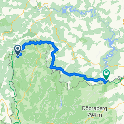
Unterhalb von Lichtenhain :)
A cycling route starting in Tettau, Bavaria, Germany.
Overview
About this route
Kalte Küche, Herr und Handelsstr., Tannenglück, Lichtenhainer Weg, Gräfenthal, Richtung Thüringer Warte, Lichtenhain, Kalte Küche
- -:--
- Duration
- 24 km
- Distance
- 625 m
- Ascent
- 625 m
- Descent
- ---
- Avg. speed
- ---
- Avg. speed
Route highlights
Points of interest along the route
Photo after 12.2 km
Blick auf Gräfenthal
Continue with Bikemap
Use, edit, or download this cycling route
You would like to ride Unterhalb von Lichtenhain :) or customize it for your own trip? Here is what you can do with this Bikemap route:
Free features
- Save this route as favorite or in collections
- Copy & plan your own version of this route
- Sync your route with Garmin or Wahoo
Premium features
Free trial for 3 days, or one-time payment. More about Bikemap Premium.
- Navigate this route on iOS & Android
- Export a GPX / KML file of this route
- Create your custom printout (try it for free)
- Download this route for offline navigation
Discover more Premium features.
Get Bikemap PremiumFrom our community
Other popular routes starting in Tettau
- Rennsteig, -Loquitztal - Taugwitztal
- Distance
- 25.6 km
- Ascent
- 435 m
- Descent
- 413 m
- Location
- Tettau, Bavaria, Germany
- Unterhalb von Lichtenhain :)
- Distance
- 24 km
- Ascent
- 625 m
- Descent
- 625 m
- Location
- Tettau, Bavaria, Germany
- In den Wäldern bei Kleintettau
- Distance
- 29.3 km
- Ascent
- 392 m
- Descent
- 392 m
- Location
- Tettau, Bavaria, Germany
- 20-8-14 Vom Rennsteig nach Kronach
- Distance
- 31.7 km
- Ascent
- 19 m
- Descent
- 369 m
- Location
- Tettau, Bavaria, Germany
- zwischen Thüringer Wald und Schiefergebirge
- Distance
- 68.1 km
- Ascent
- 844 m
- Descent
- 1,023 m
- Location
- Tettau, Bavaria, Germany
- Rund um Hasenthal
- Distance
- 21.5 km
- Ascent
- 546 m
- Descent
- 523 m
- Location
- Tettau, Bavaria, Germany
- 2022-08-11 Kleintettau nach Untersiemau
- Distance
- 55.9 km
- Ascent
- 358 m
- Descent
- 694 m
- Location
- Tettau, Bavaria, Germany
- von K`tettau nach Jagsdhof-Heinersdorf
- Distance
- 33.3 km
- Ascent
- 427 m
- Descent
- 427 m
- Location
- Tettau, Bavaria, Germany
Open it in the app