

Aachen Süd bis Ubachsberg NL
A cycling route starting in Aachen, North Rhine-Westphalia, Germany.
Overview
About this route
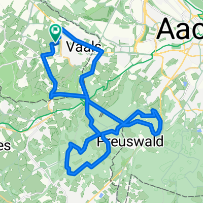
The route starts in the south of Aachen and goes through the Aachen city forest into the Netherlands. There, it runs through the Mergelland until reaching Ubachsberg. Just before Ubachsberg, about halfway, lies the Herberg de Bernardushoeve. A wonderful place to stop. Bikes can be taken onto the terrace. The terrace is huge with plenty of space, the food was delicious, the service is very friendly, and there is a lovely view of the hilly landscape of South Limburg. From here, it’s back towards Aachen. In the city, there are plenty of options to stop before heading back to the starting point.
- -:--
- Duration
- 60.1 km
- Distance
- 538 m
- Ascent
- 538 m
- Descent
- ---
- Avg. speed
- 347 m
- Max. altitude

Route quality
Waytypes & surfaces along the route
Waytypes
Quiet road
21.6 km
(36 %)
Road
18.6 km
(31 %)
Surfaces
Paved
52.9 km
(88 %)
Unpaved
1.2 km
(2 %)
Asphalt
50.5 km
(84 %)
Concrete
1.8 km
(3 %)
Route highlights
Points of interest along the route

Point of interest after 33 km
Herberg de Bernardushoeve Tolle Pausenlocation
Continue with Bikemap
Use, edit, or download this cycling route
You would like to ride Aachen Süd bis Ubachsberg NL or customize it for your own trip? Here is what you can do with this Bikemap route:
Free features
- Save this route as favorite or in collections
- Copy & plan your own version of this route
- Sync your route with Garmin or Wahoo
Premium features
Free trial for 3 days, or one-time payment. More about Bikemap Premium.
- Navigate this route on iOS & Android
- Export a GPX / KML file of this route
- Create your custom printout (try it for free)
- Download this route for offline navigation
Discover more Premium features.
Get Bikemap PremiumFrom our community
Other popular routes starting in Aachen
 Aachen Süd bis Ubachsberg NL
- Distance
- 60.1 km
- Ascent
- 538 m
- Descent
- 538 m
- Location
- Aachen, North Rhine-Westphalia, Germany
 Vaals - Op jacht in het Preuswald
- Distance
- 23.6 km
- Ascent
- 424 m
- Descent
- 425 m
- Location
- Aachen, North Rhine-Westphalia, Germany
 Grössere Eifeltour
- Distance
- 105.6 km
- Ascent
- 1,137 m
- Descent
- 1,137 m
- Location
- Aachen, North Rhine-Westphalia, Germany
 Rund um Aachen
- Distance
- 31.9 km
- Ascent
- 180 m
- Descent
- 180 m
- Location
- Aachen, North Rhine-Westphalia, Germany
 Work - Home
- Distance
- 28.9 km
- Ascent
- 319 m
- Descent
- 315 m
- Location
- Aachen, North Rhine-Westphalia, Germany
 Trainingsrunde 3(5) 2010
- Distance
- 53 km
- Ascent
- 378 m
- Descent
- 372 m
- Location
- Aachen, North Rhine-Westphalia, Germany
 kleine Wurmtalrunde
- Distance
- 24.8 km
- Ascent
- 297 m
- Descent
- 297 m
- Location
- Aachen, North Rhine-Westphalia, Germany
 aachen vtt
- Distance
- 38.9 km
- Ascent
- 512 m
- Descent
- 512 m
- Location
- Aachen, North Rhine-Westphalia, Germany
Open it in the app