
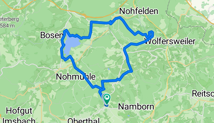
Buchwald Bike-Tour (leicht)
A cycling route starting in Oberthal, Saarland, Germany.
Overview
About this route
- -:--
- Duration
- 28.2 km
- Distance
- 357 m
- Ascent
- 360 m
- Descent
- ---
- Avg. speed
- ---
- Max. altitude

Route quality
Waytypes & surfaces along the route
Waytypes
Track
11.3 km
(40 %)
Quiet road
6.8 km
(24 %)
Surfaces
Paved
14.7 km
(52 %)
Unpaved
12.4 km
(44 %)
Asphalt
12.1 km
(43 %)
Gravel
7.1 km
(25 %)
Continue with Bikemap
Use, edit, or download this cycling route
You would like to ride Buchwald Bike-Tour (leicht) or customize it for your own trip? Here is what you can do with this Bikemap route:
Free features
- Save this route as favorite or in collections
- Copy & plan your own version of this route
- Sync your route with Garmin or Wahoo
Premium features
Free trial for 3 days, or one-time payment. More about Bikemap Premium.
- Navigate this route on iOS & Android
- Export a GPX / KML file of this route
- Create your custom printout (try it for free)
- Download this route for offline navigation
Discover more Premium features.
Get Bikemap PremiumFrom our community
Other popular routes starting in Oberthal
 Güdesw.-Buchwald-Bost.See-
- Distance
- 28.2 km
- Ascent
- 336 m
- Descent
- 342 m
- Location
- Oberthal, Saarland, Germany
 Schaumbergtrails mit Hofgut Imsbach
- Distance
- 43.8 km
- Ascent
- 849 m
- Descent
- 849 m
- Location
- Oberthal, Saarland, Germany
 RT 61km Neunkirchen(Nahe)-Thallichtenberg-Oberkirchen-Reitscheid-Assweiler-Wallhausen-Neubrücke-Nk
- Distance
- 61.1 km
- Ascent
- 1,425 m
- Descent
- 1,583 m
- Location
- Oberthal, Saarland, Germany
 Nahe-Radweg
- Distance
- 133.7 km
- Ascent
- 1,818 m
- Descent
- 2,198 m
- Location
- Oberthal, Saarland, Germany
 Güdesweiler - Bliesen - Baltersweiler
- Distance
- 15.3 km
- Ascent
- 214 m
- Descent
- 216 m
- Location
- Oberthal, Saarland, Germany
 Bostalsee/Schaumberg Runde
- Distance
- 49.7 km
- Ascent
- 578 m
- Descent
- 578 m
- Location
- Oberthal, Saarland, Germany
 Premium Feierabendtour
- Distance
- 39.8 km
- Ascent
- 688 m
- Descent
- 641 m
- Location
- Oberthal, Saarland, Germany
 WND Land (Marpingen included)
- Distance
- 46.8 km
- Ascent
- 804 m
- Descent
- 804 m
- Location
- Oberthal, Saarland, Germany
Open it in the app