

Benton Harbor Cycling
A cycling route starting in Benton Harbor, Michigan, United States.
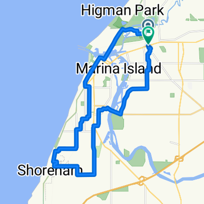
Overview
About this route
3121®
- -:--
- Duration
- 88.8 km
- Distance
- 282 m
- Ascent
- 302 m
- Descent
- ---
- Avg. speed
- 210 m
- Max. altitude

Route quality
Waytypes & surfaces along the route
Waytypes
Quiet road
13.3 km
(15 %)
Road
10.7 km
(12 %)
Surfaces
Paved
49.7 km
(56 %)
Paved (undefined)
43.5 km
(49 %)
Asphalt
6.2 km
(7 %)
Undefined
39.1 km
(44 %)
Continue with Bikemap
Use, edit, or download this cycling route
You would like to ride Benton Harbor Cycling or customize it for your own trip? Here is what you can do with this Bikemap route:
Free features
- Save this route as favorite or in collections
- Copy & plan your own version of this route
- Split it into stages to create a multi-day tour
- Sync your route with Garmin or Wahoo
Premium features
Free trial for 3 days, or one-time payment. More about Bikemap Premium.
- Navigate this route on iOS & Android
- Export a GPX / KML file of this route
- Create your custom printout (try it for free)
- Download this route for offline navigation
Discover more Premium features.
Get Bikemap PremiumFrom our community
Other popular routes starting in Benton Harbor
 Water Street to Water Street
- Distance
- 22.4 km
- Ascent
- 98 m
- Descent
- 97 m
- Location
- Benton Harbor, Michigan, United States
 877 E Main St, Benton Harbor to 1301–1373 M-63 N, Benton Harbor
- Distance
- 3.7 km
- Ascent
- 44 m
- Descent
- 10 m
- Location
- Benton Harbor, Michigan, United States
 East Empire Avenue 1503, Benton Harbor to Bent Road 10248, Marcellus
- Distance
- 65.2 km
- Ascent
- 349 m
- Descent
- 265 m
- Location
- Benton Harbor, Michigan, United States
 East Empire Avenue 1503, Benton Harbor to Pipestone Road 1920, Benton Harbor
- Distance
- 3.1 km
- Ascent
- 40 m
- Descent
- 6 m
- Location
- Benton Harbor, Michigan, United States
 Ironman Steelhead BC
- Distance
- 89.3 km
- Ascent
- 232 m
- Descent
- 230 m
- Location
- Benton Harbor, Michigan, United States

Garmin
Benton Harbor Cycling- Distance
- 88.8 km
- Ascent
- 578 m
- Descent
- 578 m
- Location
- Benton Harbor, Michigan, United States
 200 E Wall St, Benton Harbor to 106 S Huron Ave, Mackinaw City
- Distance
- 560.8 km
- Ascent
- 2,201 m
- Descent
- 2,204 m
- Location
- Benton Harbor, Michigan, United States
 East Empire Avenue 1503, Benton Harbor to Boyer Road 3228, Coloma
- Distance
- 68.7 km
- Ascent
- 328 m
- Descent
- 301 m
- Location
- Benton Harbor, Michigan, United States
Open it in the app