

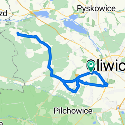
PTL Gliwice – Nędza
A cycling route starting in Żernica, Silesian Voivodeship, Poland.
Overview
About this route
Wymagająca trasa, większość leśnymi ścieżkami, po deszczu proszę doliczyć czas na grzęzawiska… Polecam, po powrocie gwarantowana satysfakcja!
- -:--
- Duration
- 93.9 km
- Distance
- 239 m
- Ascent
- 239 m
- Descent
- ---
- Avg. speed
- ---
- Max. altitude
Continue with Bikemap
Use, edit, or download this cycling route
You would like to ride PTL Gliwice – Nędza or customize it for your own trip? Here is what you can do with this Bikemap route:
Free features
- Save this route as favorite or in collections
- Copy & plan your own version of this route
- Split it into stages to create a multi-day tour
- Sync your route with Garmin or Wahoo
Premium features
Free trial for 3 days, or one-time payment. More about Bikemap Premium.
- Navigate this route on iOS & Android
- Export a GPX / KML file of this route
- Create your custom printout (try it for free)
- Download this route for offline navigation
Discover more Premium features.
Get Bikemap PremiumFrom our community
Other popular routes starting in Żernica
 Sierpniowy
- Distance
- 445.1 km
- Ascent
- 1,551 m
- Descent
- 1,574 m
- Location
- Żernica, Silesian Voivodeship, Poland
 Lekarska 3, Gliwice do Lekarska 3, Gliwice
- Distance
- 5.2 km
- Ascent
- 13 m
- Descent
- 59 m
- Location
- Żernica, Silesian Voivodeship, Poland
 09/04/2018
- Distance
- 25 km
- Ascent
- 103 m
- Descent
- 103 m
- Location
- Żernica, Silesian Voivodeship, Poland
 Nad Stawem 30, Gliwice do Nad Stawem 30, Gliwice
- Distance
- 59.2 km
- Ascent
- 228 m
- Descent
- 226 m
- Location
- Żernica, Silesian Voivodeship, Poland
 Na stawy
- Distance
- 58.9 km
- Ascent
- 210 m
- Descent
- 239 m
- Location
- Żernica, Silesian Voivodeship, Poland
 PTL Gliwice – Rybnik
- Distance
- 59.6 km
- Ascent
- 213 m
- Descent
- 215 m
- Location
- Żernica, Silesian Voivodeship, Poland
 Bargłówka - Kotlarnia - Stara Kuźnia
- Distance
- 60.9 km
- Ascent
- 166 m
- Descent
- 165 m
- Location
- Żernica, Silesian Voivodeship, Poland
 Lasami Rud Wielkich
- Distance
- 69.2 km
- Ascent
- 273 m
- Descent
- 273 m
- Location
- Żernica, Silesian Voivodeship, Poland
Open it in the app