

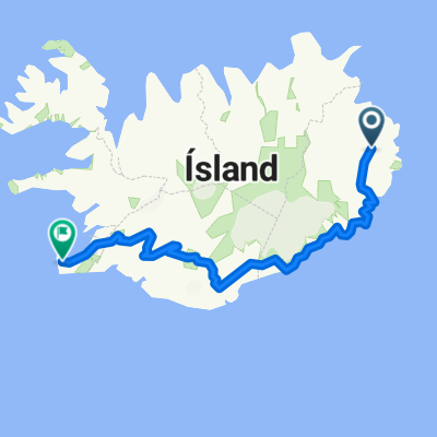
23. Egilsstaðir to Fáskrúðsfjörður
A cycling route starting in Egilsstaðir, East, Iceland.
Overview
About this route
option to go via tunnel - 35km shorter
- -:--
- Duration
- 88.1 km
- Distance
- 717 m
- Ascent
- 730 m
- Descent
- ---
- Avg. speed
- 347 m
- Max. altitude

Route quality
Waytypes & surfaces along the route
Waytypes
Busy road
43.9 km
(50 %)
Cycleway
33.2 km
(38 %)
Surfaces
Paved
70.9 km
(80 %)
Unpaved
11.1 km
(13 %)
Asphalt
70 km
(79 %)
Gravel
11.1 km
(13 %)
Route highlights
Points of interest along the route
Point of interest after 26.6 km
Búðará Canyon
Point of interest after 26.9 km
Búðarárfoss
Point of interest after 27.7 km
Icelandic Wartime Museum (Íslenska stríðsárasafnið)
Point of interest after 34.6 km
Tunnel route - 35km shorter
Point of interest after 35.7 km
Tunnel 6km dual lane Shortens trip by 35km
Point of interest after 56 km
Breiðdalsàfoss
Point of interest after 68.1 km
Vattarnesviti lighthouse private property...
Point of interest after 68.4 km
Vattarnes Sea cliffs
Point of interest after 87 km
Cimetière français
Continue with Bikemap
Use, edit, or download this cycling route
You would like to ride 23. Egilsstaðir to Fáskrúðsfjörður or customize it for your own trip? Here is what you can do with this Bikemap route:
Free features
- Save this route as favorite or in collections
- Copy & plan your own version of this route
- Split it into stages to create a multi-day tour
- Sync your route with Garmin or Wahoo
Premium features
Free trial for 3 days, or one-time payment. More about Bikemap Premium.
- Navigate this route on iOS & Android
- Export a GPX / KML file of this route
- Create your custom printout (try it for free)
- Download this route for offline navigation
Discover more Premium features.
Get Bikemap PremiumFrom our community
Other popular routes starting in Egilsstaðir
 22-Egilsstaðir_Fáskrúðsfjörður
- Distance
- 81.9 km
- Ascent
- 569 m
- Descent
- 579 m
- Location
- Egilsstaðir, East, Iceland
 22A. Egilsstaðir circuit to Hengifoss
- Distance
- 79.1 km
- Ascent
- 409 m
- Descent
- 409 m
- Location
- Egilsstaðir, East, Iceland
 Iceland: Seydisfjördur to Egilsstaðir
- Distance
- 27.6 km
- Ascent
- 665 m
- Descent
- 650 m
- Location
- Egilsstaðir, East, Iceland
 Ruta 10 islandia
- Distance
- 166.6 km
- Ascent
- 0 m
- Descent
- 0 m
- Location
- Egilsstaðir, East, Iceland
 23. Egilsstaðir to Fáskrúðsfjörður
- Distance
- 88.1 km
- Ascent
- 717 m
- Descent
- 730 m
- Location
- Egilsstaðir, East, Iceland
 ICE 2011
- Distance
- 766.8 km
- Ascent
- 1,703 m
- Descent
- 1,730 m
- Location
- Egilsstaðir, East, Iceland
 Iceland 2025 25 Egilsstaðir Seydisfjordur
- Distance
- 26.6 km
- Ascent
- 706 m
- Descent
- 719 m
- Location
- Egilsstaðir, East, Iceland
 DAY 01
- Distance
- 94.6 km
- Ascent
- 1,990 m
- Descent
- 1,904 m
- Location
- Egilsstaðir, East, Iceland
Open it in the app