

Klappental-Rundfahrt
A cycling route starting in Sondershausen, Free State of Thuringia, Germany.
Overview
About this route
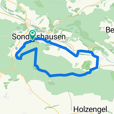
Das Klappental bietet einen gleichmäßigen Anstieg von ca. 6 km Länge und ist auch für weniger geübte Fahrer geeignet.
- -:--
- Duration
- 25.5 km
- Distance
- 344 m
- Ascent
- 267 m
- Descent
- ---
- Avg. speed
- 437 m
- Max. altitude
Route quality
Waytypes & surfaces along the route
Waytypes
Quiet road
10.7 km
(42 %)
Track
10.6 km
(42 %)
Surfaces
Paved
6.4 km
(25 %)
Unpaved
8.8 km
(35 %)
Gravel
7.3 km
(29 %)
Asphalt
5.2 km
(20 %)
Continue with Bikemap
Use, edit, or download this cycling route
You would like to ride Klappental-Rundfahrt or customize it for your own trip? Here is what you can do with this Bikemap route:
Free features
- Save this route as favorite or in collections
- Copy & plan your own version of this route
- Sync your route with Garmin or Wahoo
Premium features
Free trial for 3 days, or one-time payment. More about Bikemap Premium.
- Navigate this route on iOS & Android
- Export a GPX / KML file of this route
- Create your custom printout (try it for free)
- Download this route for offline navigation
Discover more Premium features.
Get Bikemap PremiumFrom our community
Other popular routes starting in Sondershausen
 Possenlauf 2017 MTB
- Distance
- 22.7 km
- Ascent
- 401 m
- Descent
- 397 m
- Location
- Sondershausen, Free State of Thuringia, Germany
 3-Hügel-Rundflug
- Distance
- 44.2 km
- Ascent
- 895 m
- Descent
- 854 m
- Location
- Sondershausen, Free State of Thuringia, Germany
 Klappental-Rundfahrt
- Distance
- 25.5 km
- Ascent
- 344 m
- Descent
- 267 m
- Location
- Sondershausen, Free State of Thuringia, Germany
 Possen-Hohenebra-SchwernbergerForst-Frauenberg
- Distance
- 28.7 km
- Ascent
- 489 m
- Descent
- 487 m
- Location
- Sondershausen, Free State of Thuringia, Germany
 Nachtigallenring 48, Sondershausen nach Nachtigallenring 48, Sondershausen
- Distance
- 19.8 km
- Ascent
- 231 m
- Descent
- 229 m
- Location
- Sondershausen, Free State of Thuringia, Germany
 Pfaffenteich, Stille Liebe
- Distance
- 13.1 km
- Ascent
- 419 m
- Descent
- 434 m
- Location
- Sondershausen, Free State of Thuringia, Germany
 SDH - Heringen - Aumühle - Kelbra - Auleben- SDH
- Distance
- 39.2 km
- Ascent
- 297 m
- Descent
- 294 m
- Location
- Sondershausen, Free State of Thuringia, Germany
 Rottl_Kelbra_Görsb_Aul_Schersen
- Distance
- 47.2 km
- Ascent
- 353 m
- Descent
- 358 m
- Location
- Sondershausen, Free State of Thuringia, Germany
Open it in the app