
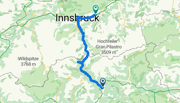
Tag08_Wattens
A cycling route starting in Sciaves, Trentino-Alto Adige, Italy.
Overview
About this route
- -:--
- Duration
- 110.3 km
- Distance
- 775 m
- Ascent
- 1,079 m
- Descent
- ---
- Avg. speed
- 1,368 m
- Max. altitude

Route quality
Waytypes & surfaces along the route
Waytypes
Busy road
30.7 km
(28 %)
Cycleway
27.5 km
(25 %)
Surfaces
Paved
89.9 km
(81 %)
Unpaved
3.3 km
(3 %)
Asphalt
88.3 km
(80 %)
Unpaved (undefined)
1.7 km
(2 %)
Continue with Bikemap
Use, edit, or download this cycling route
You would like to ride Tag08_Wattens or customize it for your own trip? Here is what you can do with this Bikemap route:
Free features
- Save this route as favorite or in collections
- Copy & plan your own version of this route
- Split it into stages to create a multi-day tour
- Sync your route with Garmin or Wahoo
Premium features
Free trial for 3 days, or one-time payment. More about Bikemap Premium.
- Navigate this route on iOS & Android
- Export a GPX / KML file of this route
- Create your custom printout (try it for free)
- Download this route for offline navigation
Discover more Premium features.
Get Bikemap PremiumFrom our community
Other popular routes starting in Sciaves
 Viums nach Eppan 2023 b
- Distance
- 63.8 km
- Ascent
- 416 m
- Descent
- 944 m
- Location
- Sciaves, Trentino-Alto Adige, Italy
 Viums zur Anraterhütte
- Distance
- 18.9 km
- Ascent
- 1,236 m
- Descent
- 321 m
- Location
- Sciaves, Trentino-Alto Adige, Italy
 Hotel Jonathan - Bhf. Mühlbach
- Distance
- 9 km
- Ascent
- 200 m
- Descent
- 336 m
- Location
- Sciaves, Trentino-Alto Adige, Italy
 Tag08_Wattens
- Distance
- 110.3 km
- Ascent
- 775 m
- Descent
- 1,079 m
- Location
- Sciaves, Trentino-Alto Adige, Italy
 Dolomitenrundfahrt
- Distance
- 383.8 km
- Ascent
- 3,664 m
- Descent
- 3,664 m
- Location
- Sciaves, Trentino-Alto Adige, Italy
 2013 Lusental
- Distance
- 44.9 km
- Ascent
- 1,195 m
- Descent
- 1,519 m
- Location
- Sciaves, Trentino-Alto Adige, Italy
 Unterbrunnergasse 26, Natz-Schabs nach Schlossergasse 30, Natz
- Distance
- 5.5 km
- Ascent
- 114 m
- Descent
- 156 m
- Location
- Sciaves, Trentino-Alto Adige, Italy
 Natz - Schloss Rodeneck -Natz
- Distance
- 19.4 km
- Ascent
- 616 m
- Descent
- 616 m
- Location
- Sciaves, Trentino-Alto Adige, Italy
Open it in the app