
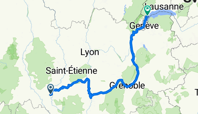
Le Puy-Grenoble-Lausanne
A cycling route starting in Le Puy-en-Velay, Auvergne-Rhône-Alpes, France.
Overview
About this route
- -:--
- Duration
- 454.8 km
- Distance
- 1,159 m
- Ascent
- 1,424 m
- Descent
- ---
- Avg. speed
- 951 m
- Avg. speed
Route quality
Waytypes & surfaces along the route
Waytypes
Quiet road
116.8 km
(26 %)
Cycleway
93.5 km
(21 %)
Surfaces
Paved
280.4 km
(62 %)
Unpaved
13.4 km
(3 %)
Asphalt
268.1 km
(59 %)
Gravel
9.6 km
(2 %)
Route highlights
Points of interest along the route
Accommodation after 43.6 km
Point of interest after 53.7 km
Unterkunft La Maison de Pierre
Accommodation after 86.4 km
Accommodation after 129.6 km
Camping Drome
Accommodation after 157.1 km
Accommodation after 159.4 km
camping municipal
Accommodation after 210.1 km
Camping Cote Vercors
Accommodation after 229.7 km
Camping les Vercors
Accommodation after 298.2 km
Camping Restaurant Lac La Terrasse
Accommodation after 340.1 km
Accommodation after 360.9 km
Accommodation after 365.7 km
Accommodation after 368.9 km
Accommodation after 377.4 km
Accommodation after 438.4 km
Accommodation after 454.5 km
Accommodation after 454.5 km
Accommodation after 454.5 km
Continue with Bikemap
Use, edit, or download this cycling route
You would like to ride Le Puy-Grenoble-Lausanne or customize it for your own trip? Here is what you can do with this Bikemap route:
Free features
- Save this route as favorite or in collections
- Copy & plan your own version of this route
- Sync your route with Garmin or Wahoo
Premium features
Free trial for 3 days, or one-time payment. More about Bikemap Premium.
- Navigate this route on iOS & Android
- Export a GPX / KML file of this route
- Create your custom printout (try it for free)
- Download this route for offline navigation
Discover more Premium features.
Get Bikemap PremiumFrom our community
Other popular routes starting in Le Puy-en-Velay
 Von le Puy-en-Velay - Pamblona
- Distance
- 733.5 km
- Ascent
- 8,996 m
- Descent
- 9,287 m
- Location
- Le Puy-en-Velay, Auvergne-Rhône-Alpes, France
 Le Puy en Velay / Saint Vincent
- Distance
- 35.9 km
- Ascent
- 220 m
- Descent
- 224 m
- Location
- Le Puy-en-Velay, Auvergne-Rhône-Alpes, France
 Jakobsweg 2018
- Distance
- 645.1 km
- Ascent
- 2,206 m
- Descent
- 2,674 m
- Location
- Le Puy-en-Velay, Auvergne-Rhône-Alpes, France
 Jakobsweg Etappe 7 - Via Podensis : Le Puy - Decazeville
- Distance
- 226 km
- Ascent
- 2,507 m
- Descent
- 2,943 m
- Location
- Le Puy-en-Velay, Auvergne-Rhône-Alpes, France
 Jakobsweg Etappe 7 - Via Podensis : Le Puy - Decazeville
- Distance
- 226 km
- Ascent
- 2,367 m
- Descent
- 2,802 m
- Location
- Le Puy-en-Velay, Auvergne-Rhône-Alpes, France
 Untitled route
- Distance
- 98.1 km
- Ascent
- 2,508 m
- Descent
- 2,095 m
- Location
- Le Puy-en-Velay, Auvergne-Rhône-Alpes, France
 Le Puy en Velay - Saint Jean Pied de Port
- Distance
- 715.6 km
- Ascent
- 2,295 m
- Descent
- 2,772 m
- Location
- Le Puy-en-Velay, Auvergne-Rhône-Alpes, France
 Tour 2010 (3)
- Distance
- 121.7 km
- Ascent
- 1,856 m
- Descent
- 1,600 m
- Location
- Le Puy-en-Velay, Auvergne-Rhône-Alpes, France
Open it in the app