

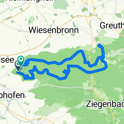
TGS Tour 26.09.21
A cycling route starting in Rödelsee, Bavaria, Germany.
Overview
About this route
Rückfahrt
- -:--
- Duration
- 158.9 km
- Distance
- 788 m
- Ascent
- 917 m
- Descent
- ---
- Avg. speed
- 432 m
- Max. altitude

Route quality
Waytypes & surfaces along the route
Waytypes
Road
66.7 km
(42 %)
Quiet road
27 km
(17 %)
Surfaces
Paved
128.7 km
(81 %)
Unpaved
4.8 km
(3 %)
Asphalt
125.5 km
(79 %)
Gravel
3.2 km
(2 %)
Continue with Bikemap
Use, edit, or download this cycling route
You would like to ride TGS Tour 26.09.21 or customize it for your own trip? Here is what you can do with this Bikemap route:
Free features
- Save this route as favorite or in collections
- Copy & plan your own version of this route
- Split it into stages to create a multi-day tour
- Sync your route with Garmin or Wahoo
Premium features
Free trial for 3 days, or one-time payment. More about Bikemap Premium.
- Navigate this route on iOS & Android
- Export a GPX / KML file of this route
- Create your custom printout (try it for free)
- Download this route for offline navigation
Discover more Premium features.
Get Bikemap PremiumFrom our community
Other popular routes starting in Rödelsee
 Mainschleife
- Distance
- 72.3 km
- Ascent
- 402 m
- Descent
- 403 m
- Location
- Rödelsee, Bavaria, Germany
 Schwanberg - Castell
- Distance
- 25.4 km
- Ascent
- 412 m
- Descent
- 403 m
- Location
- Rödelsee, Bavaria, Germany
 Reupelsdorf - Rödelsee
- Distance
- 12.2 km
- Ascent
- 49 m
- Descent
- 71 m
- Location
- Rödelsee, Bavaria, Germany
 Wanderweg: Naturpark Steigerwald, Blaues Dreieck (Rödelsee-Weingartsgreuth)
- Distance
- 43.6 km
- Ascent
- 633 m
- Descent
- 571 m
- Location
- Rödelsee, Bavaria, Germany
 TGS Tour 26.09.21
- Distance
- 158.9 km
- Ascent
- 788 m
- Descent
- 917 m
- Location
- Rödelsee, Bavaria, Germany
 Schwanberg - Castell
- Distance
- 25.4 km
- Ascent
- 412 m
- Descent
- 403 m
- Location
- Rödelsee, Bavaria, Germany
 SCF Frankentour 2 Scheinfeld
- Distance
- 67.5 km
- Ascent
- 598 m
- Descent
- 598 m
- Location
- Rödelsee, Bavaria, Germany
 Von Rödelsee bis Würzburg
- Distance
- 28.3 km
- Ascent
- 225 m
- Descent
- 267 m
- Location
- Rödelsee, Bavaria, Germany
Open it in the app