

RTTC Route
A cycling route starting in Ancaster, Ontario, Canada.
Overview
About this route
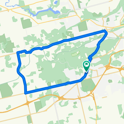
Fairweather Hamilton West-Up Wilson St.through Ancaster-To Ancaster Fair Grounds-Down Sulphur Springs to Governors Rd-Up Cootes to Fairweather Brewery.
- -:--
- Duration
- 51.5 km
- Distance
- 279 m
- Ascent
- 281 m
- Descent
- ---
- Avg. speed
- 255 m
- Max. altitude

Route quality
Waytypes & surfaces along the route
Waytypes
Road
14.4 km
(28 %)
Quiet road
12.9 km
(25 %)
Surfaces
Paved
46.9 km
(91 %)
Asphalt
45.8 km
(89 %)
Paved (undefined)
0.5 km
(1 %)
Route highlights
Points of interest along the route
Point of interest after 3.8 km
Start and Finish: Fairweather Brewery: 5 Ofield Rd., Hamilton Lots of free street parking and COLD BEER!
Point of interest after 23.7 km
Ancaster Fairgrounds: Rest and Refuel RTTC station. 630 Trinity Rd. South, Jerseyville.
Continue with Bikemap
Use, edit, or download this cycling route
You would like to ride RTTC Route or customize it for your own trip? Here is what you can do with this Bikemap route:
Free features
- Save this route as favorite or in collections
- Copy & plan your own version of this route
- Sync your route with Garmin or Wahoo
Premium features
Free trial for 3 days, or one-time payment. More about Bikemap Premium.
- Navigate this route on iOS & Android
- Export a GPX / KML file of this route
- Create your custom printout (try it for free)
- Download this route for offline navigation
Discover more Premium features.
Get Bikemap PremiumFrom our community
Other popular routes starting in Ancaster
 RTCC 2021
- Distance
- 51.1 km
- Ascent
- 251 m
- Descent
- 251 m
- Location
- Ancaster, Ontario, Canada
 Dundas Valley Perimeter
- Distance
- 24.3 km
- Ascent
- 244 m
- Descent
- 244 m
- Location
- Ancaster, Ontario, Canada
 Anc-Dun Ravel Ride
- Distance
- 18.3 km
- Ascent
- 179 m
- Descent
- 184 m
- Location
- Ancaster, Ontario, Canada
 RTTC Route
- Distance
- 51.5 km
- Ascent
- 279 m
- Descent
- 281 m
- Location
- Ancaster, Ontario, Canada
 Friends With Bikes RTCC 2021 Route
- Distance
- 54.6 km
- Ascent
- 249 m
- Descent
- 252 m
- Location
- Ancaster, Ontario, Canada
 Social Route B (Huntingdon)
- Distance
- 8 km
- Ascent
- 71 m
- Descent
- 63 m
- Location
- Ancaster, Ontario, Canada
 Hamilton bei Toronto Webster Falls
- Distance
- 1 km
- Ascent
- 50 m
- Descent
- 36 m
- Location
- Ancaster, Ontario, Canada
 Greenbelt
- Distance
- 18.1 km
- Ascent
- 182 m
- Descent
- 184 m
- Location
- Ancaster, Ontario, Canada
Open it in the app