
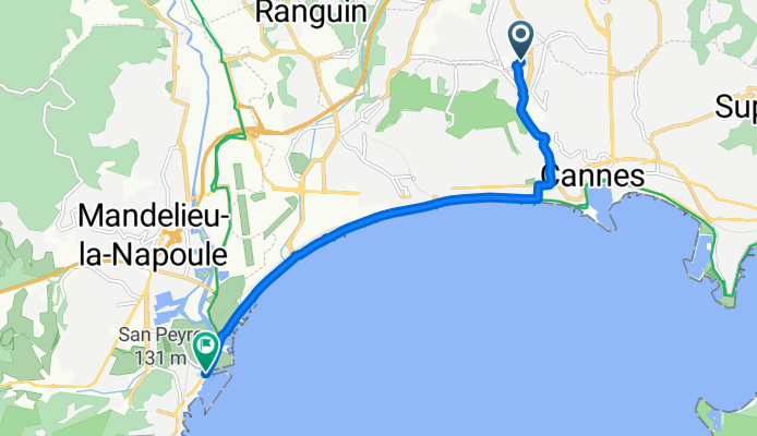
33 Chemin du Périer, Cannes to 26–266 Boulevard Henri Clews, Mandelieu-la-Napoule
A cycling route starting in Le Cannet, Provence-Alpes-Côte d'Azur Region, France.
Overview
About this route
- 28 min
- Duration
- 8.2 km
- Distance
- 30 m
- Ascent
- 103 m
- Descent
- 17.9 km/h
- Avg. speed
- ---
- Avg. speed

Route quality
Waytypes & surfaces along the route
Waytypes
Busy road
6.3 km
(77 %)
Cycleway
0.9 km
(11 %)
Surfaces
Paved
6.7 km
(82 %)
Asphalt
6.7 km
(82 %)
Undefined
1.5 km
(18 %)
Continue with Bikemap
Use, edit, or download this cycling route
You would like to ride 33 Chemin du Périer, Cannes to 26–266 Boulevard Henri Clews, Mandelieu-la-Napoule or customize it for your own trip? Here is what you can do with this Bikemap route:
Free features
- Save this route as favorite or in collections
- Copy & plan your own version of this route
- Sync your route with Garmin or Wahoo
Premium features
Free trial for 3 days, or one-time payment. More about Bikemap Premium.
- Navigate this route on iOS & Android
- Export a GPX / KML file of this route
- Create your custom printout (try it for free)
- Download this route for offline navigation
Discover more Premium features.
Get Bikemap PremiumFrom our community
Other popular routes starting in Le Cannet
 Sortie tandem 1
- Distance
- 25.8 km
- Ascent
- 417 m
- Descent
- 414 m
- Location
- Le Cannet, Provence-Alpes-Côte d'Azur Region, France
 Road trip Vélo - Jour 1/8
- Distance
- 121.1 km
- Ascent
- 1,886 m
- Descent
- 1,526 m
- Location
- Le Cannet, Provence-Alpes-Côte d'Azur Region, France
 Testanier - Tanneron
- Distance
- 70.1 km
- Ascent
- 761 m
- Descent
- 761 m
- Location
- Le Cannet, Provence-Alpes-Côte d'Azur Region, France
 Cannes Draguignan
- Distance
- 82.1 km
- Ascent
- 1,404 m
- Descent
- 1,250 m
- Location
- Le Cannet, Provence-Alpes-Côte d'Azur Region, France
 cannes nice
- Distance
- 35.3 km
- Ascent
- 784 m
- Descent
- 817 m
- Location
- Le Cannet, Provence-Alpes-Côte d'Azur Region, France
 Col de l ecre
- Distance
- 73.6 km
- Ascent
- 1,257 m
- Descent
- 1,256 m
- Location
- Le Cannet, Provence-Alpes-Côte d'Azur Region, France
 Cannet - Mougins
- Distance
- 11.5 km
- Ascent
- 205 m
- Descent
- 214 m
- Location
- Le Cannet, Provence-Alpes-Côte d'Azur Region, France
 Entrainement gorge du Loup
- Distance
- 56.8 km
- Ascent
- 684 m
- Descent
- 687 m
- Location
- Le Cannet, Provence-Alpes-Côte d'Azur Region, France
Open it in the app