

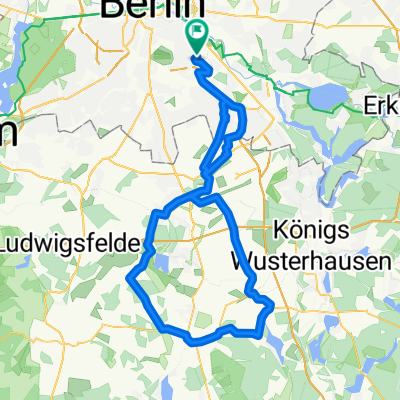
Müggelseerunde
A cycling route starting in Plänterwald, State of Berlin, Germany.
Overview
About this route
- -:--
- Duration
- 48 km
- Distance
- 71 m
- Ascent
- 69 m
- Descent
- ---
- Avg. speed
- ---
- Max. altitude
Route quality
Waytypes & surfaces along the route
Waytypes
Path
12.5 km
(26 %)
Pedestrian area
6.7 km
(14 %)
Surfaces
Paved
36 km
(75 %)
Unpaved
1.4 km
(3 %)
Asphalt
35.5 km
(74 %)
Concrete
0.5 km
(1 %)
Continue with Bikemap
Use, edit, or download this cycling route
You would like to ride Müggelseerunde or customize it for your own trip? Here is what you can do with this Bikemap route:
Free features
- Save this route as favorite or in collections
- Copy & plan your own version of this route
- Sync your route with Garmin or Wahoo
Premium features
Free trial for 3 days, or one-time payment. More about Bikemap Premium.
- Navigate this route on iOS & Android
- Export a GPX / KML file of this route
- Create your custom printout (try it for free)
- Download this route for offline navigation
Discover more Premium features.
Get Bikemap PremiumFrom our community
Other popular routes starting in Plänterwald
 Lasso-Runde
- Distance
- 91.9 km
- Ascent
- 118 m
- Descent
- 118 m
- Location
- Plänterwald, State of Berlin, Germany
 sunset funkpark runde
- Distance
- 25.6 km
- Ascent
- 29 m
- Descent
- 28 m
- Location
- Plänterwald, State of Berlin, Germany
 Rund um West-Berlin (Mauerweg RR)
- Distance
- 139.7 km
- Ascent
- 335 m
- Descent
- 332 m
- Location
- Plänterwald, State of Berlin, Germany
 Kleine BER-Runde
- Distance
- 60.7 km
- Ascent
- 64 m
- Descent
- 64 m
- Location
- Plänterwald, State of Berlin, Germany
 Rund um West-Berlin (Mauerweg RR)
- Distance
- 139.9 km
- Ascent
- 190 m
- Descent
- 185 m
- Location
- Plänterwald, State of Berlin, Germany
 Berlin - Diedersdorf - Löwenbruch - Blankenfelde - Waßmannsdorf - Berlin
- Distance
- 96.3 km
- Ascent
- 87 m
- Descent
- 87 m
- Location
- Plänterwald, State of Berlin, Germany
 Südostrunde 90 km
- Distance
- 89.8 km
- Ascent
- 196 m
- Descent
- 187 m
- Location
- Plänterwald, State of Berlin, Germany
 Rixdorf, Müggelsee, durch den Forst zurück
- Distance
- 45.7 km
- Ascent
- 62 m
- Descent
- 62 m
- Location
- Plänterwald, State of Berlin, Germany
Open it in the app