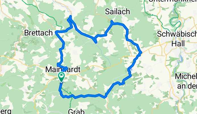
Landheg-Tour-West
A cycling route starting in Mainhardt, Baden-Württemberg, Germany.
Overview
About this route
- 2 h 21 min
- Duration
- 40.2 km
- Distance
- 473 m
- Ascent
- 473 m
- Descent
- 17.1 km/h
- Avg. speed
- 494 m
- Avg. speed
Route quality
Waytypes & surfaces along the route
Waytypes
Road
11.2 km
(28 %)
Busy road
9.3 km
(23 %)
Surfaces
Paved
27.8 km
(69 %)
Unpaved
4.6 km
(11 %)
Asphalt
27.4 km
(68 %)
Loose gravel
3 km
(7 %)
Route highlights
Points of interest along the route
Point of interest after 19.3 km
Gnadental
Point of interest after 19.7 km
Sailach-Stausee
Point of interest after 21 km
Continue with Bikemap
Use, edit, or download this cycling route
You would like to ride Landheg-Tour-West or customize it for your own trip? Here is what you can do with this Bikemap route:
Free features
- Save this route as favorite or in collections
- Copy & plan your own version of this route
- Sync your route with Garmin or Wahoo
Premium features
Free trial for 3 days, or one-time payment. More about Bikemap Premium.
- Navigate this route on iOS & Android
- Export a GPX / KML file of this route
- Create your custom printout (try it for free)
- Download this route for offline navigation
Discover more Premium features.
Get Bikemap PremiumFrom our community
Other popular routes starting in Mainhardt
- Mainhardt: Fuxi Naturerlebnispfad - Teil 1
- Distance
- 5.4 km
- Ascent
- 110 m
- Descent
- 109 m
- Location
- Mainhardt, Baden-Württemberg, Germany
- Laukenmühle - Neuhütten -Brettach
- Distance
- 13.5 km
- Ascent
- 275 m
- Descent
- 279 m
- Location
- Mainhardt, Baden-Württemberg, Germany
- Unbenannte Route
- Distance
- 4,808.8 km
- Ascent
- 30,499 m
- Descent
- 30,898 m
- Location
- Mainhardt, Baden-Württemberg, Germany
- Limes-Wanderweg Grab
- Distance
- 5.5 km
- Ascent
- 116 m
- Descent
- 117 m
- Location
- Mainhardt, Baden-Württemberg, Germany
- Route nach Im Viertel 6, Mainhardt
- Distance
- 25.4 km
- Ascent
- 270 m
- Descent
- 228 m
- Location
- Mainhardt, Baden-Württemberg, Germany
- Ett 2020 7. Etappe
- Distance
- 79.2 km
- Ascent
- 557 m
- Descent
- 796 m
- Location
- Mainhardt, Baden-Württemberg, Germany
- MTB SW Teil 3 Tough Timber Lake
- Distance
- 28.4 km
- Ascent
- 495 m
- Descent
- 495 m
- Location
- Mainhardt, Baden-Württemberg, Germany
- Mainhardt Tour 7
- Distance
- 33 km
- Ascent
- 323 m
- Descent
- 322 m
- Location
- Mainhardt, Baden-Württemberg, Germany
Open it in the app