

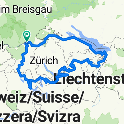
Koblenz nach Trasadingen
A cycling route starting in Koblenz, Canton of Aargau, Switzerland.
Overview
About this route
- -:--
- Duration
- 22.1 km
- Distance
- 103 m
- Ascent
- 12 m
- Descent
- ---
- Avg. speed
- 404 m
- Max. altitude
Route quality
Waytypes & surfaces along the route
Waytypes
Track
6 km
(27 %)
Path
5.7 km
(26 %)
Surfaces
Paved
17 km
(77 %)
Unpaved
2.4 km
(11 %)
Asphalt
17 km
(77 %)
Loose gravel
1.5 km
(7 %)
Continue with Bikemap
Use, edit, or download this cycling route
You would like to ride Koblenz nach Trasadingen or customize it for your own trip? Here is what you can do with this Bikemap route:
Free features
- Save this route as favorite or in collections
- Copy & plan your own version of this route
- Sync your route with Garmin or Wahoo
Premium features
Free trial for 3 days, or one-time payment. More about Bikemap Premium.
- Navigate this route on iOS & Android
- Export a GPX / KML file of this route
- Create your custom printout (try it for free)
- Download this route for offline navigation
Discover more Premium features.
Get Bikemap PremiumFrom our community
Other popular routes starting in Koblenz
 Waldshut - Lörrach
- Distance
- 68.4 km
- Ascent
- 194 m
- Descent
- 166 m
- Location
- Koblenz, Canton of Aargau, Switzerland
 Route de l'Aar
- Distance
- 301.3 km
- Ascent
- 585 m
- Descent
- 280 m
- Location
- Koblenz, Canton of Aargau, Switzerland
 1. Koblenz - Bad Säckingen (27 km)
- Distance
- 26.7 km
- Ascent
- 155 m
- Descent
- 149 m
- Location
- Koblenz, Canton of Aargau, Switzerland
 Rhein - Wannenbwerg - Wutach
- Distance
- 42.9 km
- Ascent
- 606 m
- Descent
- 603 m
- Location
- Koblenz, Canton of Aargau, Switzerland
 virée en foret noire/danube Constance etape 1 walshut lac de Titisee
- Distance
- 51 km
- Ascent
- 801 m
- Descent
- 263 m
- Location
- Koblenz, Canton of Aargau, Switzerland
 teil4 mit herzenroute 580km
- Distance
- 576.4 km
- Ascent
- 9,803 m
- Descent
- 9,803 m
- Location
- Koblenz, Canton of Aargau, Switzerland
 Hausberg Maxi
- Distance
- 48.2 km
- Ascent
- 1,044 m
- Descent
- 1,041 m
- Location
- Koblenz, Canton of Aargau, Switzerland
 Bodenseeumfahrung
- Distance
- 312.7 km
- Ascent
- 538 m
- Descent
- 538 m
- Location
- Koblenz, Canton of Aargau, Switzerland
Open it in the app