
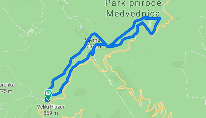
Graficar-Puntjarka-Sljeme-Graficar
A cycling route starting in Jablanovec, Zagreb County, Croatia.
Overview
About this route
The northern side of Medvednica
- -:--
- Duration
- 10.5 km
- Distance
- 329 m
- Ascent
- 326 m
- Descent
- ---
- Avg. speed
- ---
- Max. altitude

Continue with Bikemap
Use, edit, or download this cycling route
You would like to ride Graficar-Puntjarka-Sljeme-Graficar or customize it for your own trip? Here is what you can do with this Bikemap route:
Free features
- Save this route as favorite or in collections
- Copy & plan your own version of this route
- Sync your route with Garmin or Wahoo
Premium features
Free trial for 3 days, or one-time payment. More about Bikemap Premium.
- Navigate this route on iOS & Android
- Export a GPX / KML file of this route
- Create your custom printout (try it for free)
- Download this route for offline navigation
Discover more Premium features.
Get Bikemap PremiumFrom our community
Other popular routes starting in Jablanovec
 plešivica1(jablanovec-podsused-galgovo-sv. martin pod okicem-jaska-plešivica-samobor-zaprešić-jablanovec)
- Distance
- 99.6 km
- Ascent
- 848 m
- Descent
- 841 m
- Location
- Jablanovec, Zagreb County, Croatia
 Sljeme - staza 26
- Distance
- 5.2 km
- Ascent
- 305 m
- Descent
- 291 m
- Location
- Jablanovec, Zagreb County, Croatia
 D. Bistra - Sljeme - D. Bistra (MTB)
- Distance
- 30.5 km
- Ascent
- 923 m
- Descent
- 920 m
- Location
- Jablanovec, Zagreb County, Croatia
 Medvednica Pila Medvedgrad
- Distance
- 13.5 km
- Ascent
- 654 m
- Descent
- 956 m
- Location
- Jablanovec, Zagreb County, Croatia
 Gornja Bistra (rotor) - Sljeme (rotor)
- Distance
- 6 km
- Ascent
- 615 m
- Descent
- 70 m
- Location
- Jablanovec, Zagreb County, Croatia
 Osmica ponikve
- Distance
- 16.9 km
- Ascent
- 398 m
- Descent
- 736 m
- Location
- Jablanovec, Zagreb County, Croatia
 brežice (jablanovec-medsave-bregana-brežice-harmica-marija gorica-pušća-pojatno-bistra-jablanovec)
- Distance
- 68.3 km
- Ascent
- 373 m
- Descent
- 373 m
- Location
- Jablanovec, Zagreb County, Croatia
 Graficar-Puntjarka-Sljeme-Graficar
- Distance
- 10.5 km
- Ascent
- 329 m
- Descent
- 326 m
- Location
- Jablanovec, Zagreb County, Croatia
Open it in the app