

Nagy-Küküllő forrása bővített körtúra
A cycling route starting in Odorheiu Secuiesc, Harghita County, Romania.
Overview
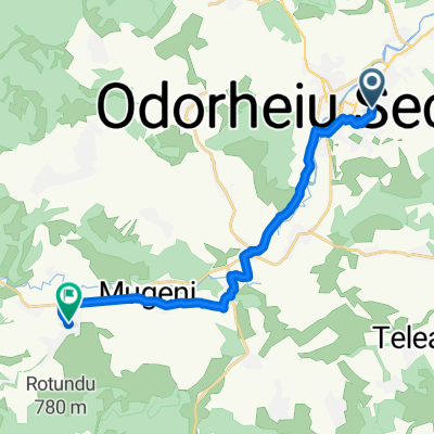
About this route
Kalonda Tetoig on asphalt, touching Szencsedet, the Tozeglapot, Tartod castle, Then back on asphalt from Varsagrol
- -:--
- Duration
- 103.3 km
- Distance
- 1,809 m
- Ascent
- 1,811 m
- Descent
- ---
- Avg. speed
- 1,435 m
- Max. altitude

Route quality
Waytypes & surfaces along the route
Waytypes
Quiet road
38.2 km
(37 %)
Track
23.8 km
(23 %)
Surfaces
Paved
44.4 km
(43 %)
Unpaved
10.3 km
(10 %)
Asphalt
44.4 km
(43 %)
Gravel
6.2 km
(6 %)
Continue with Bikemap
Use, edit, or download this cycling route
You would like to ride Nagy-Küküllő forrása bővített körtúra or customize it for your own trip? Here is what you can do with this Bikemap route:
Free features
- Save this route as favorite or in collections
- Copy & plan your own version of this route
- Split it into stages to create a multi-day tour
- Sync your route with Garmin or Wahoo
Premium features
Free trial for 3 days, or one-time payment. More about Bikemap Premium.
- Navigate this route on iOS & Android
- Export a GPX / KML file of this route
- Create your custom printout (try it for free)
- Download this route for offline navigation
Discover more Premium features.
Get Bikemap PremiumFrom our community
Other popular routes starting in Odorheiu Secuiesc
 I love my bike utvonal
- Distance
- 3.9 km
- Ascent
- 15 m
- Descent
- 36 m
- Location
- Odorheiu Secuiesc, Harghita County, Romania
 SZT / Udv.-Erked - Zoltán - Szászkézd - Udv.
- Distance
- 87.4 km
- Ascent
- 585 m
- Descent
- 591 m
- Location
- Odorheiu Secuiesc, Harghita County, Romania
 SZT / Kincskereső gyümölcsút_6
- Distance
- 11.1 km
- Ascent
- 222 m
- Descent
- 174 m
- Location
- Odorheiu Secuiesc, Harghita County, Romania
 Strada Ciocârliei - Strada Ciocârliei
- Distance
- 12.5 km
- Ascent
- 22 m
- Descent
- 61 m
- Location
- Odorheiu Secuiesc, Harghita County, Romania
 2013-Transfagarasan si Transalpina
- Distance
- 562.9 km
- Ascent
- 4,310 m
- Descent
- 4,397 m
- Location
- Odorheiu Secuiesc, Harghita County, Romania
 Budvár XC 9 km
- Distance
- 9 km
- Ascent
- 233 m
- Descent
- 232 m
- Location
- Odorheiu Secuiesc, Harghita County, Romania
 Strada Beclean, Odorheiu Secuiesc - Strada Alszeg, Martinis
- Distance
- 21.1 km
- Ascent
- 534 m
- Descent
- 505 m
- Location
- Odorheiu Secuiesc, Harghita County, Romania
 OB tol Agyagra
- Distance
- 14.1 km
- Ascent
- 91 m
- Descent
- 144 m
- Location
- Odorheiu Secuiesc, Harghita County, Romania
Open it in the app