

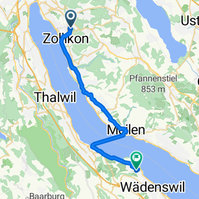
Rebwiesstrasse 4, Zollikon nach Steinacherstrasse 15, Au ZH
A cycling route starting in Zollikon, Canton of Zurich, Switzerland.
Overview
About this route
- 1 h 15 min
- Duration
- 20.1 km
- Distance
- 185 m
- Ascent
- 265 m
- Descent
- 16 km/h
- Avg. speed
- ---
- Max. altitude
Route quality
Waytypes & surfaces along the route
Waytypes
Quiet road
13.9 km
(69 %)
Cycleway
2.7 km
(14 %)
Surfaces
Paved
14.6 km
(73 %)
Unpaved
0.4 km
(2 %)
Asphalt
14.6 km
(73 %)
Loose gravel
0.4 km
(2 %)
Continue with Bikemap
Use, edit, or download this cycling route
You would like to ride Rebwiesstrasse 4, Zollikon nach Steinacherstrasse 15, Au ZH or customize it for your own trip? Here is what you can do with this Bikemap route:
Free features
- Save this route as favorite or in collections
- Copy & plan your own version of this route
- Sync your route with Garmin or Wahoo
Premium features
Free trial for 3 days, or one-time payment. More about Bikemap Premium.
- Navigate this route on iOS & Android
- Export a GPX / KML file of this route
- Create your custom printout (try it for free)
- Download this route for offline navigation
Discover more Premium features.
Get Bikemap PremiumFrom our community
Other popular routes starting in Zollikon
 Nice Route To Grimsee 03 May 2014 06:26
- Distance
- 20.9 km
- Ascent
- 526 m
- Descent
- 283 m
- Location
- Zollikon, Canton of Zurich, Switzerland
 Pfannenstiel Juni 2017
- Distance
- 20.3 km
- Ascent
- 434 m
- Descent
- 434 m
- Location
- Zollikon, Canton of Zurich, Switzerland
 Rebwiesstrasse 4, Zollikon nach Steinacherstrasse 15, Au ZH
- Distance
- 20.1 km
- Ascent
- 185 m
- Descent
- 265 m
- Location
- Zollikon, Canton of Zurich, Switzerland
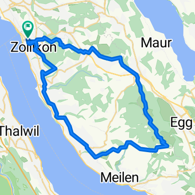 Zollikon-Pfannenstiel Rundtour
- Distance
- 29.2 km
- Ascent
- 779 m
- Descent
- 779 m
- Location
- Zollikon, Canton of Zurich, Switzerland
 Schützenstrasse 49, Zollikon nach Schlossbergstrasse 11, Zollikon
- Distance
- 189.1 km
- Ascent
- 2,289 m
- Descent
- 2,289 m
- Location
- Zollikon, Canton of Zurich, Switzerland
 Pfannenstiel Okt 2017
- Distance
- 26 km
- Ascent
- 548 m
- Descent
- 547 m
- Location
- Zollikon, Canton of Zurich, Switzerland
 Zollikerstrasse 109, Zollikon nach Spinnerei Lettenstrasse 2, Glattfelden
- Distance
- 40.4 km
- Ascent
- 408 m
- Descent
- 528 m
- Location
- Zollikon, Canton of Zurich, Switzerland
 De Bahnhofstrasse 19, Zollikon a Bahnhofstrasse 17, Zollikon
- Distance
- 14.8 km
- Ascent
- 42 m
- Descent
- 38 m
- Location
- Zollikon, Canton of Zurich, Switzerland
Open it in the app