

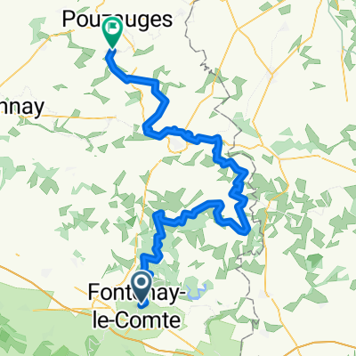
De Rue du Port 31, Fontenay-le-Comte à Rue du Port 31, Fontenay-le-Comte
A cycling route starting in Fontenay-le-Comte, Pays de la Loire Region, France.
Overview
About this route
- 4 h 8 min
- Duration
- 40.5 km
- Distance
- 14 m
- Ascent
- 21 m
- Descent
- 9.8 km/h
- Avg. speed
- ---
- Max. altitude

Route quality
Waytypes & surfaces along the route
Waytypes
Quiet road
21.1 km
(52 %)
Cycleway
8.5 km
(21 %)
Surfaces
Paved
6.9 km
(17 %)
Unpaved
2.8 km
(7 %)
Concrete
3.2 km
(8 %)
Asphalt
2.4 km
(6 %)
Continue with Bikemap
Use, edit, or download this cycling route
You would like to ride De Rue du Port 31, Fontenay-le-Comte à Rue du Port 31, Fontenay-le-Comte or customize it for your own trip? Here is what you can do with this Bikemap route:
Free features
- Save this route as favorite or in collections
- Copy & plan your own version of this route
- Sync your route with Garmin or Wahoo
Premium features
Free trial for 3 days, or one-time payment. More about Bikemap Premium.
- Navigate this route on iOS & Android
- Export a GPX / KML file of this route
- Create your custom printout (try it for free)
- Download this route for offline navigation
Discover more Premium features.
Get Bikemap PremiumFrom our community
Other popular routes starting in Fontenay-le-Comte
 Day 4 13th June
- Distance
- 107.8 km
- Ascent
- 280 m
- Descent
- 265 m
- Location
- Fontenay-le-Comte, Pays de la Loire Region, France
 Recording from 27 Apr 2017, 17.43
- Distance
- 133 km
- Ascent
- 165 m
- Descent
- 176 m
- Location
- Fontenay-le-Comte, Pays de la Loire Region, France
 France2023 E28
- Distance
- 71 km
- Ascent
- 923 m
- Descent
- 827 m
- Location
- Fontenay-le-Comte, Pays de la Loire Region, France
 FONTENAY CHARRON
- Distance
- 41 km
- Ascent
- 64 m
- Descent
- 80 m
- Location
- Fontenay-le-Comte, Pays de la Loire Region, France
 De Allée de la Vallée Verte à D105E1
- Distance
- 42.5 km
- Ascent
- 82 m
- Descent
- 141 m
- Location
- Fontenay-le-Comte, Pays de la Loire Region, France
 Fontenay-le-Comte - La Meilleraie-Tillay
- Distance
- 86.4 km
- Ascent
- 1,006 m
- Descent
- 893 m
- Location
- Fontenay-le-Comte, Pays de la Loire Region, France
 Fontenay forest loop
- Distance
- 26.3 km
- Ascent
- 284 m
- Descent
- 248 m
- Location
- Fontenay-le-Comte, Pays de la Loire Region, France
 Parcours du 14 juillet (inédit)
- Distance
- 91.2 km
- Ascent
- 492 m
- Descent
- 492 m
- Location
- Fontenay-le-Comte, Pays de la Loire Region, France
Open it in the app