

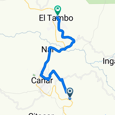
De F3QC+MGV, El Tambo a Ramón Borrero, El Tambo
A cycling route starting in Cañar, Cañar, Ecuador.
Overview
About this route
- 2 h 18 min
- Duration
- 37.3 km
- Distance
- 2,224 m
- Ascent
- 2,221 m
- Descent
- 16.2 km/h
- Avg. speed
- ---
- Max. altitude

Route photos


Route quality
Waytypes & surfaces along the route
Waytypes
Quiet road
36.5 km
(98 %)
Cycleway
0.7 km
(2 %)
Surfaces
Paved
2.2 km
(6 %)
Unpaved
0.4 km
(1 %)
Asphalt
2.2 km
(6 %)
Unpaved (undefined)
0.4 km
(1 %)
Undefined
34.7 km
(93 %)
Continue with Bikemap
Use, edit, or download this cycling route
You would like to ride De F3QC+MGV, El Tambo a Ramón Borrero, El Tambo or customize it for your own trip? Here is what you can do with this Bikemap route:
Free features
- Save this route as favorite or in collections
- Copy & plan your own version of this route
- Sync your route with Garmin or Wahoo
Premium features
Free trial for 3 days, or one-time payment. More about Bikemap Premium.
- Navigate this route on iOS & Android
- Export a GPX / KML file of this route
- Create your custom printout (try it for free)
- Download this route for offline navigation
Discover more Premium features.
Get Bikemap PremiumFrom our community
Other popular routes starting in Cañar
 De F3QC+MGV, El Tambo a Ramón Borrero, El Tambo
- Distance
- 37.3 km
- Ascent
- 2,224 m
- Descent
- 2,221 m
- Location
- Cañar, Cañar, Ecuador
 Vía a Ingapirca, El Tambo a Carrera Ingapirca, El Tambo
- Distance
- 30.6 km
- Ascent
- 1,060 m
- Descent
- 1,078 m
- Location
- Cañar, Cañar, Ecuador
 Cañar Radfahren
- Distance
- 75.8 km
- Ascent
- 817 m
- Descent
- 1,409 m
- Location
- Cañar, Cañar, Ecuador
 Paseo lento
- Distance
- 5.5 km
- Ascent
- 51 m
- Descent
- 329 m
- Location
- Cañar, Cañar, Ecuador
 Panamericana, Canar a Ramón Borrero, El Tambo
- Distance
- 14.8 km
- Ascent
- 227 m
- Descent
- 608 m
- Location
- Cañar, Cañar, Ecuador
 Cuenca
- Distance
- 65.6 km
- Ascent
- 733 m
- Descent
- 1,328 m
- Location
- Cañar, Cañar, Ecuador
 Ecuador 11 / Canar - Cuenca
- Distance
- 55 km
- Ascent
- 974 m
- Descent
- 1,632 m
- Location
- Cañar, Cañar, Ecuador
 2016Ecuador17_11-19
- Distance
- 74.6 km
- Ascent
- 1,502 m
- Descent
- 1,910 m
- Location
- Cañar, Cañar, Ecuador
Open it in the app