

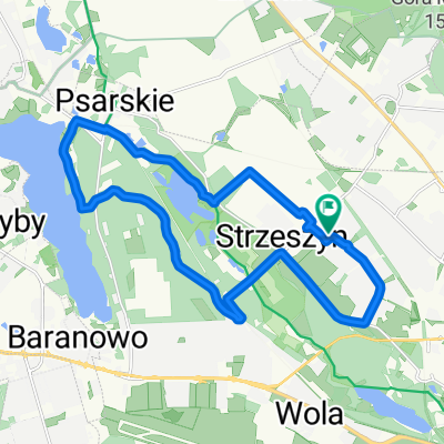
Północny-zachód Poznania
A cycling route starting in Suchy Las, Greater Poland Voivodeship, Poland.
Overview
About this route
- -:--
- Duration
- 107.7 km
- Distance
- 107 m
- Ascent
- 107 m
- Descent
- ---
- Avg. speed
- ---
- Max. altitude
Route quality
Waytypes & surfaces along the route
Waytypes
Road
51.7 km
(48 %)
Quiet road
17.2 km
(16 %)
Surfaces
Paved
79.7 km
(74 %)
Unpaved
4.3 km
(4 %)
Asphalt
76.5 km
(71 %)
Paved (undefined)
3.2 km
(3 %)
Route highlights
Points of interest along the route

Photo after 40.3 km
Jadąc drogą do Czyśćca, rzeczywiście można by odkupić jakiś grzech.

Photo after 57.6 km
Tutaj już była nawrotka i jazda do domu.

Photo after 58 km
Kapliczka

Photo after 58.3 km
Nadleśnictwo Pniewy, strasznie atakowało tutaj robactwo. Chciałem w tym miejscu doładować sobie cukru, ale trzeba było uciekać.

Photo after 70.1 km
Był Czyściec a tu trafiłem do "piekła".
Continue with Bikemap
Use, edit, or download this cycling route
You would like to ride Północny-zachód Poznania or customize it for your own trip? Here is what you can do with this Bikemap route:
Free features
- Save this route as favorite or in collections
- Copy & plan your own version of this route
- Split it into stages to create a multi-day tour
- Sync your route with Garmin or Wahoo
Premium features
Free trial for 3 days, or one-time payment. More about Bikemap Premium.
- Navigate this route on iOS & Android
- Export a GPX / KML file of this route
- Create your custom printout (try it for free)
- Download this route for offline navigation
Discover more Premium features.
Get Bikemap PremiumFrom our community
Other popular routes starting in Suchy Las
 Moliera, Poznań do Moliera, Poznań
- Distance
- 18.1 km
- Ascent
- 131 m
- Descent
- 137 m
- Location
- Suchy Las, Greater Poland Voivodeship, Poland
 Północny-zachód Poznania
- Distance
- 107.7 km
- Ascent
- 107 m
- Descent
- 107 m
- Location
- Suchy Las, Greater Poland Voivodeship, Poland
 Poznań - Wełna szuter
- Distance
- 110.5 km
- Ascent
- 322 m
- Descent
- 323 m
- Location
- Suchy Las, Greater Poland Voivodeship, Poland
 Ring 100KM
- Distance
- 95.5 km
- Ascent
- 480 m
- Descent
- 478 m
- Location
- Suchy Las, Greater Poland Voivodeship, Poland
 Koszalińska, Poznań to Koszalińska, Poznań
- Distance
- 15.3 km
- Ascent
- 129 m
- Descent
- 121 m
- Location
- Suchy Las, Greater Poland Voivodeship, Poland
 Pętla przez 3 jeziora
- Distance
- 36.5 km
- Ascent
- 153 m
- Descent
- 153 m
- Location
- Suchy Las, Greater Poland Voivodeship, Poland
 1.05.2022
- Distance
- 21 km
- Ascent
- 100 m
- Descent
- 100 m
- Location
- Suchy Las, Greater Poland Voivodeship, Poland
 Polna, Suchy Las do Wiśniowa, Trzek
- Distance
- 44.8 km
- Ascent
- 208 m
- Descent
- 225 m
- Location
- Suchy Las, Greater Poland Voivodeship, Poland
Open it in the app