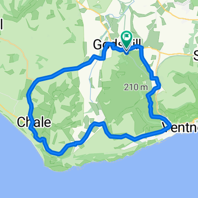
Chillerton Tour - Via Whitwell & Roud
- 35.4 km
- 347 m
- 348 m
- Ventnor, England, United Kingdom
A cycling route starting in Ventnor, England, United Kingdom.
Overview
Great classic, Sunday morning ride! Always lots of other riders to pass and say hi! 35km but only gentle climbs apart from Kingates Lane which is rather steep at the top, west end - look out for angry cars along the 'beautifully finished' Newport Road. A great drive along the Appleford Rd towards Chale then another short climb up Town Lane and into Emmett Hill. Stunning views always from Emmett Hill out toward the West Wight, Chillerton (notice the radio mast @ 1800 ft.) & Limmerstone. From Highwood Lane loop back to Rookley and the Chequers Inn, Niton Road > Southford Lane then back to the camp site at Wroxall. #wroxall #campsite #camping #isleofwightcycleroute #ventnor #appuldurcombe
created this 4 years ago
Route quality
Road
27.6 km
(78 %)
Quiet road
1.1 km
(3 %)
Undefined
6.7 km
(19 %)
Paved
35.4 km
(100 %)
Asphalt
35.4 km
(100 %)
Continue with Bikemap
You would like to ride Chillerton Tour - Via Whitwell & Roud or customize it for your own trip? Here is what you can do with this Bikemap route:
Free trial for 3 days, or one-time payment. More about Bikemap Premium.
Discover more Premium features.
Get Bikemap PremiumFrom our community
Open it in the app