

la nocturne vtt (37 et 20 km)
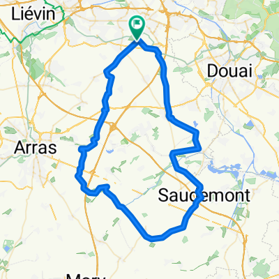
A cycling route starting in Drocourt, Hauts-de-France, France.
Overview
About this route
route with start, finish, feed zone and 10 safety points
- -:--
- Duration
- 36.9 km
- Distance
- 120 m
- Ascent
- 120 m
- Descent
- ---
- Avg. speed
- ---
- Max. altitude
Route highlights
Points of interest along the route
Point of interest after 4.9 km
1 point de secu
Point of interest after 6.2 km
2 point de secu
Point of interest after 9.6 km
3 point de secu
Point of interest after 11.5 km
4 point de secu
Point of interest after 14 km
5 point de secu
Point of interest after 18.3 km
6 point de secu
Point of interest after 20.5 km
7 point de secu
Point of interest after 20.5 km
ravito
Point of interest after 28 km
8 point de secu
Point of interest after 30.6 km
9 point de secu
Point of interest after 35.1 km
10 point de secu
Point of interest after 36.9 km
départ et arrivée salle polyvalente route d'yzel
Continue with Bikemap
Use, edit, or download this cycling route
You would like to ride la nocturne vtt (37 et 20 km) or customize it for your own trip? Here is what you can do with this Bikemap route:
Free features
- Save this route as favorite or in collections
- Copy & plan your own version of this route
- Sync your route with Garmin or Wahoo
Premium features
Free trial for 3 days, or one-time payment. More about Bikemap Premium.
- Navigate this route on iOS & Android
- Export a GPX / KML file of this route
- Create your custom printout (try it for free)
- Download this route for offline navigation
Discover more Premium features.
Get Bikemap PremiumFrom our community
Other popular routes starting in Drocourt
 la nocturne vtt (37 et 20 km)
- Distance
- 36.9 km
- Ascent
- 120 m
- Descent
- 120 m
- Location
- Drocourt, Hauts-de-France, France
 65 km par vis en artois
- Distance
- 65.2 km
- Ascent
- 250 m
- Descent
- 247 m
- Location
- Drocourt, Hauts-de-France, France
 droàcourtoise vtt 2018
- Distance
- 50.4 km
- Ascent
- 102 m
- Descent
- 105 m
- Location
- Drocourt, Hauts-de-France, France
 rando g matagne 57km route
- Distance
- 57.1 km
- Ascent
- 183 m
- Descent
- 183 m
- Location
- Drocourt, Hauts-de-France, France
 67 km g matagne 2014 route
- Distance
- 66.7 km
- Ascent
- 235 m
- Descent
- 235 m
- Location
- Drocourt, Hauts-de-France, France
 rando g matagne 45km route
- Distance
- 45 km
- Ascent
- 175 m
- Descent
- 173 m
- Location
- Drocourt, Hauts-de-France, France
 parcours g matagne route 84km
- Distance
- 83.3 km
- Ascent
- 230 m
- Descent
- 230 m
- Location
- Drocourt, Hauts-de-France, France
 vtt 52 kms
- Distance
- 52.1 km
- Ascent
- 135 m
- Descent
- 135 m
- Location
- Drocourt, Hauts-de-France, France
Open it in the app