

Plattelandsrit vanuit Dijon
A cycling route starting in Dijon, Bourgogne-Franche-Comté, France.
Overview
About this route
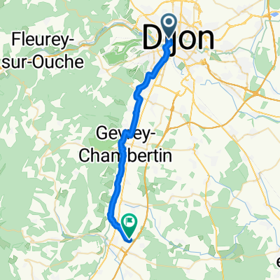
Deze fietsroute start en eindigt aan het station van Dijon en neemt je direct mee naar de oase van rust die het platteland omheen Dijon vormt. Mooie wegen, glooiende velden en groene bossen zijn hier schering en inslag, wat perfect is om er een leuke fietstocht te maken.
- -:--
- Duration
- 39.6 km
- Distance
- 516 m
- Ascent
- 515 m
- Descent
- ---
- Avg. speed
- ---
- Max. altitude
Route quality
Waytypes & surfaces along the route
Waytypes
Busy road
10.7 km
(27 %)
Road
9.8 km
(25 %)
Surfaces
Paved
32 km
(81 %)
Unpaved
2.2 km
(6 %)
Asphalt
31.7 km
(80 %)
Gravel
2.2 km
(6 %)
Continue with Bikemap
Use, edit, or download this cycling route
You would like to ride Plattelandsrit vanuit Dijon or customize it for your own trip? Here is what you can do with this Bikemap route:
Free features
- Save this route as favorite or in collections
- Copy & plan your own version of this route
- Sync your route with Garmin or Wahoo
Premium features
Free trial for 3 days, or one-time payment. More about Bikemap Premium.
- Navigate this route on iOS & Android
- Export a GPX / KML file of this route
- Create your custom printout (try it for free)
- Download this route for offline navigation
Discover more Premium features.
Get Bikemap PremiumFrom our community
Other popular routes starting in Dijon
 Toul Le-Puy Etappe 4 Dijon Beaune
- Distance
- 43.7 km
- Ascent
- 132 m
- Descent
- 164 m
- Location
- Dijon, Bourgogne-Franche-Comté, France
 Dijon-Pasques-Val-Suzon
- Distance
- 49.9 km
- Ascent
- 573 m
- Descent
- 482 m
- Location
- Dijon, Bourgogne-Franche-Comté, France
 Plattelandsrit vanuit Dijon
- Distance
- 39.6 km
- Ascent
- 516 m
- Descent
- 515 m
- Location
- Dijon, Bourgogne-Franche-Comté, France
 De Cour de la gare à La Berchère
- Distance
- 26.6 km
- Ascent
- 157 m
- Descent
- 168 m
- Location
- Dijon, Bourgogne-Franche-Comté, France
 Girolibero: Il canale di Borgogna / Da Digione a Auxerre
- Distance
- 241.9 km
- Ascent
- 212 m
- Descent
- 364 m
- Location
- Dijon, Bourgogne-Franche-Comté, France
 La Cras - Velars - La Pérouse
- Distance
- 26.6 km
- Ascent
- 435 m
- Descent
- 434 m
- Location
- Dijon, Bourgogne-Franche-Comté, France
 Tour 4 maggio
- Distance
- 67.2 km
- Ascent
- 448 m
- Descent
- 468 m
- Location
- Dijon, Bourgogne-Franche-Comté, France
 Girolibero: Borgogna da Digione a Tournus
- Distance
- 120.3 km
- Ascent
- 231 m
- Descent
- 275 m
- Location
- Dijon, Bourgogne-Franche-Comté, France
Open it in the app