

DEDINKY 2
A cycling route starting in Dobšiná, Košice Region, Slovakia.
Overview
About this route
- -:--
- Duration
- 66.9 km
- Distance
- 921 m
- Ascent
- 906 m
- Descent
- ---
- Avg. speed
- ---
- Max. altitude

Route quality
Waytypes & surfaces along the route
Waytypes
Road
4 km
(6 %)
Quiet road
2 km
(3 %)
Surfaces
Paved
26.8 km
(40 %)
Unpaved
2 km
(3 %)
Asphalt
26.8 km
(40 %)
Ground
1.3 km
(2 %)
Continue with Bikemap
Use, edit, or download this cycling route
You would like to ride DEDINKY 2 or customize it for your own trip? Here is what you can do with this Bikemap route:
Free features
- Save this route as favorite or in collections
- Copy & plan your own version of this route
- Sync your route with Garmin or Wahoo
Premium features
Free trial for 3 days, or one-time payment. More about Bikemap Premium.
- Navigate this route on iOS & Android
- Export a GPX / KML file of this route
- Create your custom printout (try it for free)
- Download this route for offline navigation
Discover more Premium features.
Get Bikemap PremiumFrom our community
Other popular routes starting in Dobšiná
 SK/Telgárt - PL/Zakopane
- Distance
- 98.8 km
- Ascent
- 1,877 m
- Descent
- 1,820 m
- Location
- Dobšiná, Košice Region, Slovakia
 Telgárt, Telgárt až Telgárt, Telgárt
- Distance
- 48.5 km
- Ascent
- 1,792 m
- Descent
- 1,791 m
- Location
- Dobšiná, Košice Region, Slovakia
 MTB MARATON MLYNKY 2012
- Distance
- 61.5 km
- Ascent
- 0 m
- Descent
- 0 m
- Location
- Dobšiná, Košice Region, Slovakia
 Zelená stuha Horehronia
- Distance
- 54.8 km
- Ascent
- 979 m
- Descent
- 1,246 m
- Location
- Dobšiná, Košice Region, Slovakia
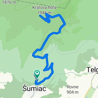 Kráľova Hoľa
- Distance
- 23.8 km
- Ascent
- 1,024 m
- Descent
- 1,009 m
- Location
- Dobšiná, Košice Region, Slovakia
 Dedinky - Stratená - Stratenský kaňon - Dobšinská Maša - Dedinky CLONED FROM ROUTE 582102
- Distance
- 14.3 km
- Ascent
- 449 m
- Descent
- 445 m
- Location
- Dobšiná, Košice Region, Slovakia
 Telgárt, Telgárt až Muráň
- Distance
- 21.6 km
- Ascent
- 667 m
- Descent
- 694 m
- Location
- Dobšiná, Košice Region, Slovakia
 Šumiac, Kráľová Hoľa, Bartková,Pohorelá Šumiac
- Distance
- 39.1 km
- Ascent
- 1,338 m
- Descent
- 1,337 m
- Location
- Dobšiná, Košice Region, Slovakia
Open it in the app