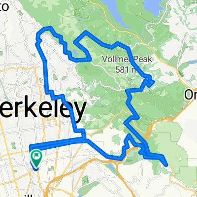
Sir Climbs-a-Lot (Centennial Remix)
A cycling route starting in Emeryville, California, United States.
Overview
About this route
Based on my Sir Climbs-a-Lot route, but with Centennial Dr. replacing Broadway Terr.
- -:--
- Duration
- 65.7 km
- Distance
- 1,021 m
- Ascent
- 1,023 m
- Descent
- ---
- Avg. speed
- ---
- Max. altitude
Route quality
Waytypes & surfaces along the route
Waytypes
Road
26.9 km
(41 %)
Quiet road
13.8 km
(21 %)
Surfaces
Paved
44.7 km
(68 %)
Asphalt
44 km
(67 %)
Paved (undefined)
0.7 km
(1 %)
Undefined
21 km
(32 %)
Continue with Bikemap
Use, edit, or download this cycling route
You would like to ride Sir Climbs-a-Lot (Centennial Remix) or customize it for your own trip? Here is what you can do with this Bikemap route:
Free features
- Save this route as favorite or in collections
- Copy & plan your own version of this route
- Sync your route with Garmin or Wahoo
Premium features
Free trial for 3 days, or one-time payment. More about Bikemap Premium.
- Navigate this route on iOS & Android
- Export a GPX / KML file of this route
- Create your custom printout (try it for free)
- Download this route for offline navigation
Discover more Premium features.
Get Bikemap PremiumFrom our community
Other popular routes starting in Emeryville
- Park-Pinehurst Loop
- Distance
- 47.5 km
- Ascent
- 678 m
- Descent
- 676 m
- Location
- Emeryville, California, United States
- evening mash
- Distance
- 38.3 km
- Ascent
- 3 m
- Descent
- 17 m
- Location
- Emeryville, California, United States
- Bay Trail to Shoreline
- Distance
- 11.8 km
- Ascent
- 42 m
- Descent
- 45 m
- Location
- Emeryville, California, United States
- west oak loop
- Distance
- 25.4 km
- Ascent
- 485 m
- Descent
- 482 m
- Location
- Emeryville, California, United States
- Lake Merritt
- Distance
- 4.2 km
- Ascent
- 4 m
- Descent
- 4 m
- Location
- Emeryville, California, United States
- Pt Richmond Loop
- Distance
- 25.1 km
- Ascent
- 0 m
- Descent
- 0 m
- Location
- Emeryville, California, United States
- Skyline trek along Redwood Park, southwest side
- Distance
- 31.8 km
- Ascent
- 521 m
- Descent
- 521 m
- Location
- Emeryville, California, United States
- Hill Loop
- Distance
- 40.1 km
- Ascent
- 691 m
- Descent
- 689 m
- Location
- Emeryville, California, United States
Open it in the app