

Lusolle: SOURCES DE MONCAUT
A cycling route starting in Cazaubon, Languedoc-Roussillon-Midi-Pyrénées, France.
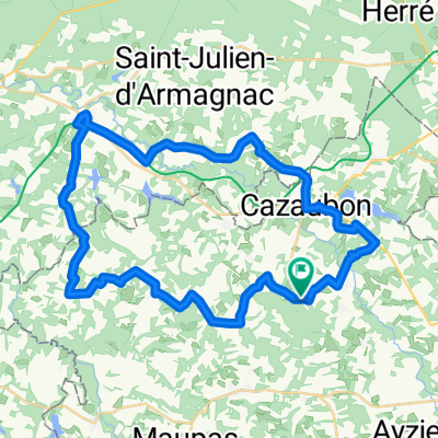
Overview
About this route
Boucle Larée/La Bastide d'A/ Vielle Soubir/
- -:--
- Duration
- 83.6 km
- Distance
- 217 m
- Ascent
- 217 m
- Descent
- ---
- Avg. speed
- 162 m
- Avg. speed

Route quality
Waytypes & surfaces along the route
Waytypes
Road
64.4 km
(77 %)
Quiet road
13.6 km
(16 %)
Surfaces
Paved
2.6 km
(3 %)
Unpaved
2.9 km
(3 %)
Unpaved (undefined)
2.9 km
(3 %)
Asphalt
2.6 km
(3 %)
Undefined
78.1 km
(93 %)
Route highlights
Points of interest along the route
Point of interest after 23.8 km
PLACE PICNIC
Point of interest after 46.6 km
Chemin gravier qui mène aux "Sources de Moncaut"
Point of interest after 47.9 km
Boucle à faire à pied... trop difficile en vélo à cause du sable...
Point of interest after 48.8 km
SOURCES DE MONCAUT
Point of interest after 51.7 km
Fin du chemin gravier
Point of interest after 55.1 km
chemin sableux
Continue with Bikemap
Use, edit, or download this cycling route
You would like to ride Lusolle: SOURCES DE MONCAUT or customize it for your own trip? Here is what you can do with this Bikemap route:
Free features
- Save this route as favorite or in collections
- Copy & plan your own version of this route
- Sync your route with Garmin or Wahoo
Premium features
Free trial for 3 days, or one-time payment. More about Bikemap Premium.
- Navigate this route on iOS & Android
- Export a GPX / KML file of this route
- Create your custom printout (try it for free)
- Download this route for offline navigation
Discover more Premium features.
Get Bikemap PremiumFrom our community
Other popular routes starting in Cazaubon
 Deutschland - Portugal (Berlin - Faro) FR 30 Cazaubon - Mont-de-Marsan
- Distance
- 42.9 km
- Ascent
- 259 m
- Descent
- 339 m
- Location
- Cazaubon, Languedoc-Roussillon-Midi-Pyrénées, France
 Lusolle: SOURCES DE MONCAUT
- Distance
- 83.6 km
- Ascent
- 217 m
- Descent
- 217 m
- Location
- Cazaubon, Languedoc-Roussillon-Midi-Pyrénées, France
 Itinéraire reposant en Villeneuve-de-Marsan
- Distance
- 14.9 km
- Ascent
- 132 m
- Descent
- 144 m
- Location
- Cazaubon, Languedoc-Roussillon-Midi-Pyrénées, France
 ´Jakobsweg 17. Etappe
- Distance
- 87.8 km
- Ascent
- 407 m
- Descent
- 451 m
- Location
- Cazaubon, Languedoc-Roussillon-Midi-Pyrénées, France
 2015 Ride Day 35 - Labastide d'Armagnac to Le Passage-d'Agen
- Distance
- 85.5 km
- Ascent
- 507 m
- Descent
- 532 m
- Location
- Cazaubon, Languedoc-Roussillon-Midi-Pyrénées, France
 RANDONNEE ABC DE LAREE
- Distance
- 50 km
- Ascent
- 401 m
- Descent
- 433 m
- Location
- Cazaubon, Languedoc-Roussillon-Midi-Pyrénées, France
 J5 - Labastide / Mont de Marsan
- Distance
- 31.8 km
- Ascent
- 160 m
- Descent
- 200 m
- Location
- Cazaubon, Languedoc-Roussillon-Midi-Pyrénées, France
 ESTOURES/LAREE/ESCOUBES/CAZAUBON/MAUVEZIN D'A/LABASTIDE D'A/LANNEMAGNAN/MAULEON D'A/MONCLAR/LAREE (ESTOURES)
- Distance
- 45 km
- Ascent
- 233 m
- Descent
- 231 m
- Location
- Cazaubon, Languedoc-Roussillon-Midi-Pyrénées, France
Open it in the app