
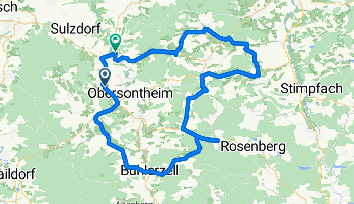
Fischachtal + Frankenhardter Wald CLONED FROM ROUTE 189180
A cycling route starting in Obersontheim, Baden-Wurttemberg, Germany.
Overview
About this route
Eine landschaftlich sehr reizvolle Strecke. Aufgrund des geringen Verkehrs ist sie meine Lieblingsstrecke. Steigungen von 8 bis 10 % sind ebenso vorhanden wie z.T. lange relativ flache Streckenabschnitte.
- -:--
- Duration
- 57.7 km
- Distance
- 423 m
- Ascent
- 437 m
- Descent
- ---
- Avg. speed
- ---
- Max. altitude
Route quality
Waytypes & surfaces along the route
Waytypes
Road
25.8 km
(45 %)
Busy road
24 km
(42 %)
Surfaces
Paved
25.9 km
(45 %)
Asphalt
23.3 km
(40 %)
Paved (undefined)
2.6 km
(5 %)
Undefined
31.8 km
(55 %)
Continue with Bikemap
Use, edit, or download this cycling route
You would like to ride Fischachtal + Frankenhardter Wald CLONED FROM ROUTE 189180 or customize it for your own trip? Here is what you can do with this Bikemap route:
Free features
- Save this route as favorite or in collections
- Copy & plan your own version of this route
- Sync your route with Garmin or Wahoo
Premium features
Free trial for 3 days, or one-time payment. More about Bikemap Premium.
- Navigate this route on iOS & Android
- Export a GPX / KML file of this route
- Create your custom printout (try it for free)
- Download this route for offline navigation
Discover more Premium features.
Get Bikemap PremiumFrom our community
Other popular routes starting in Obersontheim
 Fischachtal + Frankenhardter Wald
- Distance
- 57.7 km
- Ascent
- 584 m
- Descent
- 590 m
- Location
- Obersontheim, Baden-Wurttemberg, Germany
 Route 2
- Distance
- 45.2 km
- Ascent
- 455 m
- Descent
- 454 m
- Location
- Obersontheim, Baden-Wurttemberg, Germany
 Bühlerursprung
- Distance
- 54.5 km
- Ascent
- 451 m
- Descent
- 452 m
- Location
- Obersontheim, Baden-Wurttemberg, Germany
 Obersontheim - Altenberg - Obersontheim
- Distance
- 40 km
- Ascent
- 463 m
- Descent
- 463 m
- Location
- Obersontheim, Baden-Wurttemberg, Germany
 Fischachtal + Frankenhardter Wald CLONED FROM ROUTE 189180
- Distance
- 57.7 km
- Ascent
- 423 m
- Descent
- 437 m
- Location
- Obersontheim, Baden-Wurttemberg, Germany
 Route 3
- Distance
- 31.1 km
- Ascent
- 235 m
- Descent
- 236 m
- Location
- Obersontheim, Baden-Wurttemberg, Germany
 Gaildorfer Straße nach Im Bergfeld
- Distance
- 38.4 km
- Ascent
- 347 m
- Descent
- 384 m
- Location
- Obersontheim, Baden-Wurttemberg, Germany
 Haller Touren 12 - Vellberg
- Distance
- 46.5 km
- Ascent
- 608 m
- Descent
- 600 m
- Location
- Obersontheim, Baden-Wurttemberg, Germany
Open it in the app