
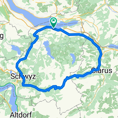
Stöcklichrüz
A cycling route starting in Altendorf, Canton of Schwyz, Switzerland.
Overview
About this route
Strenger aufstieg, schöne ausicht oben und ein richtig schöner flowiger trail runter
aber halt sehr viel wanderer Respekt!!!
- -:--
- Duration
- 17.1 km
- Distance
- 1,182 m
- Ascent
- 960 m
- Descent
- ---
- Avg. speed
- 1,232 m
- Max. altitude
Route quality
Waytypes & surfaces along the route
Waytypes
Track
6.7 km
(39 %)
Quiet road
5.6 km
(33 %)
Surfaces
Paved
6.1 km
(36 %)
Unpaved
2.8 km
(16 %)
Paved (undefined)
3.9 km
(23 %)
Asphalt
2.2 km
(13 %)
Route highlights
Points of interest along the route

Point of interest after 11.2 km
Sunset

Point of interest after 11.3 km
trail richtung Lachen
Continue with Bikemap
Use, edit, or download this cycling route
You would like to ride Stöcklichrüz or customize it for your own trip? Here is what you can do with this Bikemap route:
Free features
- Save this route as favorite or in collections
- Copy & plan your own version of this route
- Sync your route with Garmin or Wahoo
Premium features
Free trial for 3 days, or one-time payment. More about Bikemap Premium.
- Navigate this route on iOS & Android
- Export a GPX / KML file of this route
- Create your custom printout (try it for free)
- Download this route for offline navigation
Discover more Premium features.
Get Bikemap PremiumFrom our community
Other popular routes starting in Altendorf
 Stöcklichrüz
- Distance
- 17.1 km
- Ascent
- 1,182 m
- Descent
- 960 m
- Location
- Altendorf, Canton of Schwyz, Switzerland
 Lange Ausfahrt von Altendorf nach Lachen SZ
- Distance
- 31.7 km
- Ascent
- 1,161 m
- Descent
- 1,177 m
- Location
- Altendorf, Canton of Schwyz, Switzerland
 Lachen-Sattelegg
- Distance
- 30.1 km
- Ascent
- 1,018 m
- Descent
- 1,017 m
- Location
- Altendorf, Canton of Schwyz, Switzerland
 Alpen 2012 - Pragelpass
- Distance
- 110.6 km
- Ascent
- 1,682 m
- Descent
- 1,682 m
- Location
- Altendorf, Canton of Schwyz, Switzerland
 Tour mit Urs
- Distance
- 70.2 km
- Ascent
- 2,047 m
- Descent
- 2,046 m
- Location
- Altendorf, Canton of Schwyz, Switzerland
 der Grabentrail
- Distance
- 13.4 km
- Ascent
- 710 m
- Descent
- 606 m
- Location
- Altendorf, Canton of Schwyz, Switzerland
 Lachen - Meinrad - Stöcklichrüz - Lachen
- Distance
- 20.9 km
- Ascent
- 834 m
- Descent
- 829 m
- Location
- Altendorf, Canton of Schwyz, Switzerland
 Obersee
- Distance
- 34.4 km
- Ascent
- 260 m
- Descent
- 275 m
- Location
- Altendorf, Canton of Schwyz, Switzerland
Open it in the app