

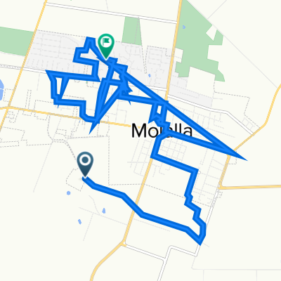
Trout Creek - Molalla - Feyrer Park - Home
A cycling route starting in Molalla, Oregon, United States of America.
Overview
About this route
Loop to Molalla by way of Trout Creek Rd. back home by Dickey Prairie Rd.
- -:--
- Duration
- 30.2 km
- Distance
- 388 m
- Ascent
- 388 m
- Descent
- ---
- Avg. speed
- 428 m
- Max. altitude
Route quality
Waytypes & surfaces along the route
Waytypes
Road
17.9 km
(59 %)
Busy road
6.8 km
(23 %)
Surfaces
Paved
0 km
(<1 %)
Asphalt
0 km
(<1 %)
Undefined
30.2 km
(100 %)
Continue with Bikemap
Use, edit, or download this cycling route
You would like to ride Trout Creek - Molalla - Feyrer Park - Home or customize it for your own trip? Here is what you can do with this Bikemap route:
Free features
- Save this route as favorite or in collections
- Copy & plan your own version of this route
- Sync your route with Garmin or Wahoo
Premium features
Free trial for 3 days, or one-time payment. More about Bikemap Premium.
- Navigate this route on iOS & Android
- Export a GPX / KML file of this route
- Create your custom printout (try it for free)
- Download this route for offline navigation
Discover more Premium features.
Get Bikemap PremiumFrom our community
Other popular routes starting in Molalla
 Trout Creek - Molalla - Feyrer Park - Home
- Distance
- 30.2 km
- Ascent
- 388 m
- Descent
- 388 m
- Location
- Molalla, Oregon, United States of America
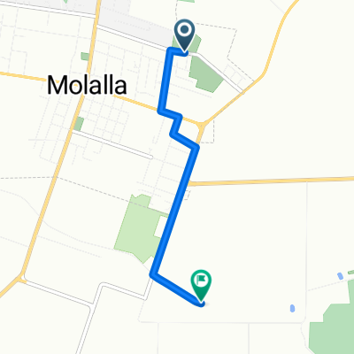
 32067 S Shady Dell Rd, Molalla to S Mullala Rd, Molalla
- Distance
- 22.7 km
- Ascent
- 513 m
- Descent
- 294 m
- Location
- Molalla, Oregon, United States of America
 Home to the Barn
- Distance
- 12.6 km
- Ascent
- 13 m
- Descent
- 78 m
- Location
- Molalla, Oregon, United States of America
 South Molalla Forest Road 13388 to Julie Lane 816, Molalla
- Distance
- 19.7 km
- Ascent
- 47 m
- Descent
- 55 m
- Location
- Molalla, Oregon, United States of America
 West Main Street 1535, Molalla to Ridings Avenue 517, Molalla
- Distance
- 2.3 km
- Ascent
- 11 m
- Descent
- 0 m
- Location
- Molalla, Oregon, United States of America
 712 Shirley St, Molalla to S Molalla Forest Rd, Molalla
- Distance
- 2.9 km
- Ascent
- 25 m
- Descent
- 22 m
- Location
- Molalla, Oregon, United States of America
 Molalla To Rogue River - Siskiyou NF
- Distance
- 589.5 km
- Ascent
- 2,596 m
- Descent
- 2,206 m
- Location
- Molalla, Oregon, United States of America
 Molalla River Corridor
- Distance
- 21.9 km
- Ascent
- 214 m
- Descent
- 214 m
- Location
- Molalla, Oregon, United States of America
Open it in the app