

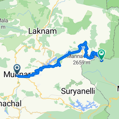
2022_IN.01.06.0_Munnar_Theni.NH85_79km730hm
A cycling route starting in Munnar, Kerala, India.
Overview
About this route
- -:--
- Duration
- 78.8 km
- Distance
- 610 m
- Ascent
- 1,767 m
- Descent
- ---
- Avg. speed
- 1,712 m
- Max. altitude

Continue with Bikemap
Use, edit, or download this cycling route
You would like to ride 2022_IN.01.06.0_Munnar_Theni.NH85_79km730hm or customize it for your own trip? Here is what you can do with this Bikemap route:
Free features
- Save this route as favorite or in collections
- Copy & plan your own version of this route
- Sync your route with Garmin or Wahoo
Premium features
Free trial for 3 days, or one-time payment. More about Bikemap Premium.
- Navigate this route on iOS & Android
- Export a GPX / KML file of this route
- Create your custom printout (try it for free)
- Download this route for offline navigation
Discover more Premium features.
Get Bikemap PremiumFrom our community
Other popular routes starting in Munnar
 2022_IN.01.06.0_Munnar_Theni.NH85_79km730hm
- Distance
- 78.8 km
- Ascent
- 610 m
- Descent
- 1,767 m
- Location
- Munnar, Kerala, India
 india 10
- Distance
- 128.4 km
- Ascent
- 223 m
- Descent
- 1,672 m
- Location
- Munnar, Kerala, India
 Munnar-MunnarTopStation
- Distance
- 35.1 km
- Ascent
- 771 m
- Descent
- 368 m
- Location
- Munnar, Kerala, India
 Devikulam to Bodinayakkanur
- Distance
- 47.8 km
- Ascent
- 2,450 m
- Descent
- 2,099 m
- Location
- Munnar, Kerala, India
 8/12 bis
- Distance
- 24.6 km
- Ascent
- 931 m
- Descent
- 1,834 m
- Location
- Munnar, Kerala, India
 Route to Koviloor Village
- Distance
- 76.1 km
- Ascent
- 3,392 m
- Descent
- 3,185 m
- Location
- Munnar, Kerala, India
 3) Adimali - Munnar
- Distance
- 29.5 km
- Ascent
- 1,246 m
- Descent
- 346 m
- Location
- Munnar, Kerala, India
 Steady ride in
- Distance
- 14.4 km
- Ascent
- 375 m
- Descent
- 352 m
- Location
- Munnar, Kerala, India
Open it in the app