

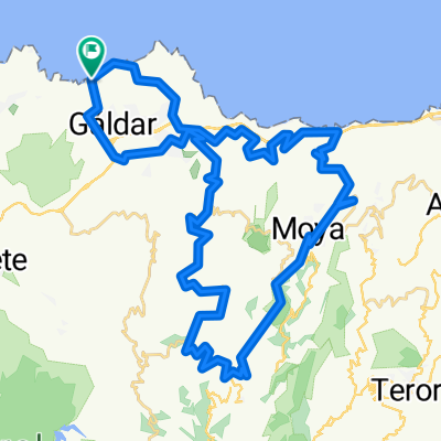
agujero punta de galdar botija y barranco de galdar
A cycling route starting in Gáldar, Canary Islands, Spain.
Overview
About this route
Start from El Agujero beach, route along the coast to Punta de Gáldar, from there to Sardina del Norte heading towards Llanos de Botija, we exit at the highway junction, go down through the vicinity of the Los Quintana neighborhood, and from there descend the entire ravine until reaching Bocabarranco beach and then back to the starting point.
- -:--
- Duration
- 23 km
- Distance
- 403 m
- Ascent
- 403 m
- Descent
- ---
- Avg. speed
- ---
- Max. altitude
Continue with Bikemap
Use, edit, or download this cycling route
You would like to ride agujero punta de galdar botija y barranco de galdar or customize it for your own trip? Here is what you can do with this Bikemap route:
Free features
- Save this route as favorite or in collections
- Copy & plan your own version of this route
- Sync your route with Garmin or Wahoo
Premium features
Free trial for 3 days, or one-time payment. More about Bikemap Premium.
- Navigate this route on iOS & Android
- Export a GPX / KML file of this route
- Create your custom printout (try it for free)
- Download this route for offline navigation
Discover more Premium features.
Get Bikemap PremiumFrom our community
Other popular routes starting in Gáldar
 Gáldar-La Atalaya-Sardina-Hoya Pineda-Marmolejo-Gáldar
- Distance
- 29.8 km
- Ascent
- 480 m
- Descent
- 480 m
- Location
- Gáldar, Canary Islands, Spain
 Paseo por el Noroeste
- Distance
- 26.9 km
- Ascent
- 419 m
- Descent
- 419 m
- Location
- Gáldar, Canary Islands, Spain
 EL AGUJERO,MONTAÑA ALTA, LOS TILOS
- Distance
- 58.5 km
- Ascent
- 1,253 m
- Descent
- 1,254 m
- Location
- Gáldar, Canary Islands, Spain
 Entre Plataneras Del Norte
- Distance
- 21.5 km
- Ascent
- 353 m
- Descent
- 350 m
- Location
- Gáldar, Canary Islands, Spain
 GALDAR-ARTENARA-AGAETE-GALDAR
- Distance
- 77.2 km
- Ascent
- 1,740 m
- Descent
- 1,742 m
- Location
- Gáldar, Canary Islands, Spain
 Espagne 2 : Gáldar - Las Palmas de Gran Canaria (TTT)
- Distance
- 40.5 km
- Ascent
- 614 m
- Descent
- 554 m
- Location
- Gáldar, Canary Islands, Spain
 13.08.15
- Distance
- 51.9 km
- Ascent
- 1,204 m
- Descent
- 1,201 m
- Location
- Gáldar, Canary Islands, Spain
 Municipal Guía
- Distance
- 12.9 km
- Ascent
- 411 m
- Descent
- 258 m
- Location
- Gáldar, Canary Islands, Spain
Open it in the app