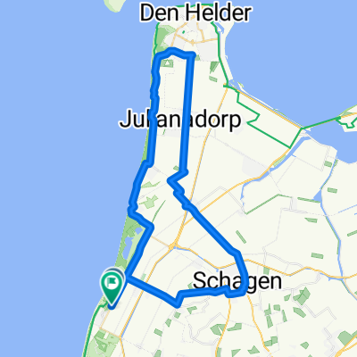
P02-Schagen-31km
A cycling route starting in Harenkarspel, North Holland, The Netherlands.
Overview
About this route
- -:--
- Duration
- 30.8 km
- Distance
- 14 m
- Ascent
- 19 m
- Descent
- ---
- Avg. speed
- 10 m
- Max. altitude
Route quality
Waytypes & surfaces along the route
Waytypes
Cycleway
17.2 km
(56 %)
Quiet road
7.7 km
(25 %)
Surfaces
Paved
12.9 km
(42 %)
Unpaved
2.5 km
(8 %)
Asphalt
12.3 km
(40 %)
Gravel
1.5 km
(5 %)
Route highlights
Points of interest along the route
Point of interest after 15.6 km
Schagen
Continue with Bikemap
Use, edit, or download this cycling route
You would like to ride P02-Schagen-31km or customize it for your own trip? Here is what you can do with this Bikemap route:
Free features
- Save this route as favorite or in collections
- Copy & plan your own version of this route
- Sync your route with Garmin or Wahoo
Premium features
Free trial for 3 days, or one-time payment. More about Bikemap Premium.
- Navigate this route on iOS & Android
- Export a GPX / KML file of this route
- Create your custom printout (try it for free)
- Download this route for offline navigation
Discover more Premium features.
Get Bikemap PremiumFrom our community
Other popular routes starting in Harenkarspel
- Rekerlanden 127, Warmenhuizen nach Rekerlanden 114, Warmenhuizen
- Distance
- 27 km
- Ascent
- 44 m
- Descent
- 40 m
- Location
- Harenkarspel, North Holland, The Netherlands
- 2003 Ardennen
- Distance
- 878.6 km
- Ascent
- 1,053 m
- Descent
- 1,050 m
- Location
- Harenkarspel, North Holland, The Netherlands
- Hargen
- Distance
- 28.1 km
- Ascent
- 90 m
- Descent
- 87 m
- Location
- Harenkarspel, North Holland, The Netherlands
- 3/9/14 Rondje rondom Tuitjenhorn (div)
- Distance
- 27.2 km
- Ascent
- 0 m
- Descent
- 0 m
- Location
- Harenkarspel, North Holland, The Netherlands
- Lekker de Schoorlse Duinen door (fietsroute: 552983) - route.nl
- Distance
- 52.4 km
- Ascent
- 53 m
- Descent
- 53 m
- Location
- Harenkarspel, North Holland, The Netherlands
- From Oudkarspel to Arnhem
- Distance
- 144.4 km
- Ascent
- 128 m
- Descent
- 84 m
- Location
- Harenkarspel, North Holland, The Netherlands
- Rondje WF Dijk Stolpen Ruigeweg
- Distance
- 26.7 km
- Ascent
- 0 m
- Descent
- 0 m
- Location
- Harenkarspel, North Holland, The Netherlands
- P04-Schoorl-Tuitjenhorn-31km
- Distance
- 30.9 km
- Ascent
- 43 m
- Descent
- 46 m
- Location
- Harenkarspel, North Holland, The Netherlands
Open it in the app