

MTB-Flach: Ossiachersee/Annenheim - Drauradweg (Rosental)
A cycling route starting in Wernberg, Carinthia, Austria.
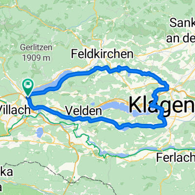
Overview
About this route
Schöne Roll-Etappe, ohne Verkehr.
Verbindung Ossiachersee - Drauradweg antlang dem Seebach (Ossiachersee-Ausfluss).
Ab St. Magdalen (Anschluss Drauradweg) immer entlang des Drauradwegs.
Ausnahme: Bei Rosegg/Emmersdorf die Drau über das Kraftwerk queren. Bundesstrasse queren und vor der Brücke wieder rechts auf Schotterweg einbiegen. Rechts entlang des Verbindungskanals (Kanal liegt linkerhand) bis man bei Dolintschach wieder auf den Drauradweg trifft.
Umkehrpunkt willkürlich vor dem Schotterwerk nahe St. Oswald getroffen. Einkehrmöglichkeit ein kurzes Stück weiter Richtung Ferlach im Gasthaus Rosentalerstüberl, direkt am Drauradweg.
Hinweis: Der Drauradweg führt von dort natürlich weiter in Richtung Ferlach.
Auf gleicher Route zurück zum Ossiachersee.
- -:--
- Duration
- 31.3 km
- Distance
- 136 m
- Ascent
- 170 m
- Descent
- ---
- Avg. speed
- ---
- Max. altitude

Continue with Bikemap
Use, edit, or download this cycling route
You would like to ride MTB-Flach: Ossiachersee/Annenheim - Drauradweg (Rosental) or customize it for your own trip? Here is what you can do with this Bikemap route:
Free features
- Save this route as favorite or in collections
- Copy & plan your own version of this route
- Sync your route with Garmin or Wahoo
Premium features
Free trial for 3 days, or one-time payment. More about Bikemap Premium.
- Navigate this route on iOS & Android
- Export a GPX / KML file of this route
- Create your custom printout (try it for free)
- Download this route for offline navigation
Discover more Premium features.
Get Bikemap PremiumFrom our community
Other popular routes starting in Wernberg
 Faaker See - Wörthersee
- Distance
- 43.8 km
- Ascent
- 329 m
- Descent
- 325 m
- Location
- Wernberg, Carinthia, Austria
 Seenrunde
- Distance
- 56.7 km
- Ascent
- 340 m
- Descent
- 340 m
- Location
- Wernberg, Carinthia, Austria
 KärtnerSeen-1.Etappe
- Distance
- 34.7 km
- Ascent
- 90 m
- Descent
- 227 m
- Location
- Wernberg, Carinthia, Austria
 Kärntner Seenrunde
- Distance
- 83.3 km
- Ascent
- 909 m
- Descent
- 915 m
- Location
- Wernberg, Carinthia, Austria
 22. Gerlizen Bergtour
- Distance
- 47.1 km
- Ascent
- 1,574 m
- Descent
- 1,574 m
- Location
- Wernberg, Carinthia, Austria
 🚴♀️E*Bike🇦🇹 2.Tag Ossiachersee-Fakersee
- Distance
- 51 km
- Ascent
- 154 m
- Descent
- 247 m
- Location
- Wernberg, Carinthia, Austria
 Alpe Adria MTB Giro_NEU!!!
- Distance
- 88.7 km
- Ascent
- 1,958 m
- Descent
- 2,014 m
- Location
- Wernberg, Carinthia, Austria
 🚴♀️E*Bike🇦🇹 Villach-Klagenfurt-Völkermarkt (Alternative)
- Distance
- 71 km
- Ascent
- 325 m
- Descent
- 387 m
- Location
- Wernberg, Carinthia, Austria
Open it in the app