

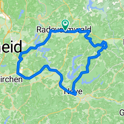
Runde Röntgenlauf
A cycling route starting in Radevormwald, North Rhine-Westphalia, Germany.
Overview
About this route
- -:--
- Duration
- 62.2 km
- Distance
- 1,152 m
- Ascent
- 1,191 m
- Descent
- ---
- Avg. speed
- 350 m
- Max. altitude

Route quality
Waytypes & surfaces along the route
Waytypes
Track
27.5 km
(44 %)
Quiet road
13.5 km
(22 %)
Surfaces
Paved
23.2 km
(37 %)
Unpaved
28.4 km
(46 %)
Asphalt
22.3 km
(36 %)
Gravel
18.6 km
(30 %)
Continue with Bikemap
Use, edit, or download this cycling route
You would like to ride Runde Röntgenlauf or customize it for your own trip? Here is what you can do with this Bikemap route:
Free features
- Save this route as favorite or in collections
- Copy & plan your own version of this route
- Sync your route with Garmin or Wahoo
Premium features
Free trial for 3 days, or one-time payment. More about Bikemap Premium.
- Navigate this route on iOS & Android
- Export a GPX / KML file of this route
- Create your custom printout (try it for free)
- Download this route for offline navigation
Discover more Premium features.
Get Bikemap PremiumFrom our community
Other popular routes starting in Radevormwald
 Tannenbergweg 3, Radevormwald nach Tannenbergweg 3, Radevormwald
- Distance
- 4.2 km
- Ascent
- 4 m
- Descent
- 23 m
- Location
- Radevormwald, North Rhine-Westphalia, Germany
 Rund um die Wuppertalsperre
- Distance
- 23.1 km
- Ascent
- 397 m
- Descent
- 429 m
- Location
- Radevormwald, North Rhine-Westphalia, Germany
 R2 - Entlang der Ülfe und der Wupper
- Distance
- 25.6 km
- Ascent
- 276 m
- Descent
- 276 m
- Location
- Radevormwald, North Rhine-Westphalia, Germany
 Rund um das Bismarck Museum 2019
- Distance
- 44.5 km
- Ascent
- 407 m
- Descent
- 406 m
- Location
- Radevormwald, North Rhine-Westphalia, Germany
 Adler CTF Herbert
- Distance
- 57.1 km
- Ascent
- 583 m
- Descent
- 583 m
- Location
- Radevormwald, North Rhine-Westphalia, Germany
 27.11.2010 Krähwinkel 1 Rund um die Wuppertalsperre
- Distance
- 19.8 km
- Ascent
- 259 m
- Descent
- 259 m
- Location
- Radevormwald, North Rhine-Westphalia, Germany
 Kräwinkel - Marscheider Bachtal
- Distance
- 41.7 km
- Ascent
- 648 m
- Descent
- 647 m
- Location
- Radevormwald, North Rhine-Westphalia, Germany
 Von Talsperren und Bahntrassen– Graveln im Bergischen
- Distance
- 48.8 km
- Ascent
- 474 m
- Descent
- 476 m
- Location
- Radevormwald, North Rhine-Westphalia, Germany
Open it in the app