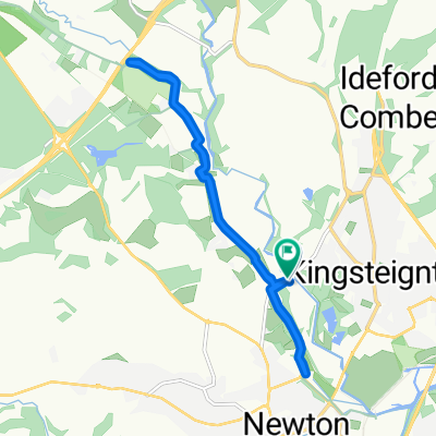
tuesday short route
A cycling route starting in Kingsteignton, England, United Kingdom.
Overview
About this route
- -:--
- Duration
- 39.5 km
- Distance
- 556 m
- Ascent
- 560 m
- Descent
- ---
- Avg. speed
- 254 m
- Avg. speed
Route quality
Waytypes & surfaces along the route
Waytypes
Quiet road
27.3 km
(69 %)
Cycleway
8.4 km
(21 %)
Surfaces
Paved
14.9 km
(38 %)
Unpaved
1.5 km
(4 %)
Asphalt
14.9 km
(38 %)
Gravel
1.2 km
(3 %)
Continue with Bikemap
Use, edit, or download this cycling route
You would like to ride tuesday short route or customize it for your own trip? Here is what you can do with this Bikemap route:
Free features
- Save this route as favorite or in collections
- Copy & plan your own version of this route
- Sync your route with Garmin or Wahoo
Premium features
Free trial for 3 days, or one-time payment. More about Bikemap Premium.
- Navigate this route on iOS & Android
- Export a GPX / KML file of this route
- Create your custom printout (try it for free)
- Download this route for offline navigation
Discover more Premium features.
Get Bikemap PremiumFrom our community
Other popular routes starting in Kingsteignton
- Teigngrace, Newton Abbot to Knowle Road, Lustleigh, Newton Abbot
- Distance
- 11.1 km
- Ascent
- 137 m
- Descent
- 77 m
- Location
- Kingsteignton, England, United Kingdom
- on the Stover.
- Distance
- 10.9 km
- Ascent
- 254 m
- Descent
- 261 m
- Location
- Kingsteignton, England, United Kingdom
- 3 Pipistrelle Way, Newton Abbot to 1–3 Fore St, Kingsteignton, Newton Abbot
- Distance
- 37.8 km
- Ascent
- 518 m
- Descent
- 521 m
- Location
- Kingsteignton, England, United Kingdom
- Up to the moors and back down Teign valley
- Distance
- 60.3 km
- Ascent
- 1,044 m
- Descent
- 1,058 m
- Location
- Kingsteignton, England, United Kingdom
- Kingsteignton - Moretonhampstead loop
- Distance
- 43 km
- Ascent
- 449 m
- Descent
- 449 m
- Location
- Kingsteignton, England, United Kingdom
- Teignmouth/Shaldon loop
- Distance
- 19.9 km
- Ascent
- 234 m
- Descent
- 231 m
- Location
- Kingsteignton, England, United Kingdom
- tuesday short route
- Distance
- 39.5 km
- Ascent
- 556 m
- Descent
- 560 m
- Location
- Kingsteignton, England, United Kingdom
- Helipad money raiser. Kingsteignton to callow end
- Distance
- 283.3 km
- Ascent
- 447 m
- Descent
- 466 m
- Location
- Kingsteignton, England, United Kingdom
Open it in the app