

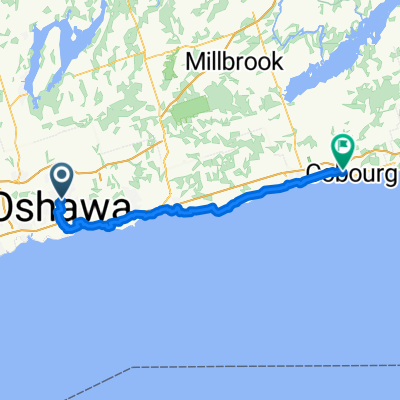
643 Lakeview Ave, Oshawa to 647 Lakeview Ave, Oshawa
A cycling route starting in Oshawa, Ontario, Canada.
Overview
About this route
- 1 h 8 min
- Duration
- 17.6 km
- Distance
- 62 m
- Ascent
- 61 m
- Descent
- 15.5 km/h
- Avg. speed
- ---
- Max. altitude

Route photos


Route quality
Waytypes & surfaces along the route
Waytypes
Cycleway
15.4 km
(88 %)
Quiet road
0.7 km
(4 %)
Surfaces
Paved
16.8 km
(96 %)
Asphalt
15.6 km
(89 %)
Wood
1.1 km
(6 %)
Continue with Bikemap
Use, edit, or download this cycling route
You would like to ride 643 Lakeview Ave, Oshawa to 647 Lakeview Ave, Oshawa or customize it for your own trip? Here is what you can do with this Bikemap route:
Free features
- Save this route as favorite or in collections
- Copy & plan your own version of this route
- Sync your route with Garmin or Wahoo
Premium features
Free trial for 3 days, or one-time payment. More about Bikemap Premium.
- Navigate this route on iOS & Android
- Export a GPX / KML file of this route
- Create your custom printout (try it for free)
- Download this route for offline navigation
Discover more Premium features.
Get Bikemap PremiumFrom our community
Other popular routes starting in Oshawa
 Bowman Ave, Whitby to Bradley Dr, Whitby
- Distance
- 15.4 km
- Ascent
- 25 m
- Descent
- 40 m
- Location
- Oshawa, Ontario, Canada
 Toronto
- Distance
- 73.3 km
- Ascent
- 492 m
- Descent
- 523 m
- Location
- Oshawa, Ontario, Canada
 Stewart St, Whitby to Anderson St, Whitby
- Distance
- 23.9 km
- Ascent
- 38 m
- Descent
- 46 m
- Location
- Oshawa, Ontario, Canada
 Oshawa - Omemee
- Distance
- 51.5 km
- Ascent
- 593 m
- Descent
- 535 m
- Location
- Oshawa, Ontario, Canada
 Mary Street North 1140, Oshawa to Simcoe Street South 1615, Oshawa
- Distance
- 10.7 km
- Ascent
- 45 m
- Descent
- 104 m
- Location
- Oshawa, Ontario, Canada
 643 Lakeview Ave, Oshawa to 647 Lakeview Ave, Oshawa
- Distance
- 17.6 km
- Ascent
- 62 m
- Descent
- 61 m
- Location
- Oshawa, Ontario, Canada
 Willoughby Pl, Clarington to Willoughby Pl, Clarington
- Distance
- 10.9 km
- Ascent
- 71 m
- Descent
- 72 m
- Location
- Oshawa, Ontario, Canada
 Late afternoon ride session☀️|Great Lakes Waterfront Trail, Bowmanville to Great Lakes Waterfront Trail, Bowmanville
- Distance
- 18.9 km
- Ascent
- 109 m
- Descent
- 109 m
- Location
- Oshawa, Ontario, Canada
Open it in the app