

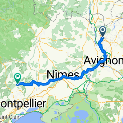
Orange-Villedieu
A cycling route starting in Orange, Provence-Alpes-Côte d'Azur Region, France.
Overview
About this route
- -:--
- Duration
- 80 km
- Distance
- 432 m
- Ascent
- 433 m
- Descent
- ---
- Avg. speed
- ---
- Max. altitude

Route quality
Waytypes & surfaces along the route
Waytypes
Road
33.6 km
(42 %)
Quiet road
11.2 km
(14 %)
Surfaces
Paved
39.2 km
(49 %)
Unpaved
2.4 km
(3 %)
Asphalt
39.2 km
(49 %)
Gravel
1.6 km
(2 %)
Continue with Bikemap
Use, edit, or download this cycling route
You would like to ride Orange-Villedieu or customize it for your own trip? Here is what you can do with this Bikemap route:
Free features
- Save this route as favorite or in collections
- Copy & plan your own version of this route
- Sync your route with Garmin or Wahoo
Premium features
Free trial for 3 days, or one-time payment. More about Bikemap Premium.
- Navigate this route on iOS & Android
- Export a GPX / KML file of this route
- Create your custom printout (try it for free)
- Download this route for offline navigation
Discover more Premium features.
Get Bikemap PremiumFrom our community
Other popular routes starting in Orange
 around Mt. Ventoux - max. beautifull!
- Distance
- 156.4 km
- Ascent
- 1,068 m
- Descent
- 1,068 m
- Location
- Orange, Provence-Alpes-Côte d'Azur Region, France
 Rhone Bike Tour
- Distance
- 27 km
- Ascent
- 141 m
- Descent
- 146 m
- Location
- Orange, Provence-Alpes-Côte d'Azur Region, France
 Ventoux via Vaison/Malaucene
- Distance
- 123.2 km
- Ascent
- 1,918 m
- Descent
- 1,918 m
- Location
- Orange, Provence-Alpes-Côte d'Azur Region, France
 Orange
- Distance
- 45.6 km
- Ascent
- 289 m
- Descent
- 243 m
- Location
- Orange, Provence-Alpes-Côte d'Azur Region, France
 Tag_1_Fahrt nach Vaison la Romanie
- Distance
- 38.4 km
- Ascent
- 260 m
- Descent
- 71 m
- Location
- Orange, Provence-Alpes-Côte d'Azur Region, France
 Orange - St-Mathieu de Treviers
- Distance
- 137.1 km
- Ascent
- 233 m
- Descent
- 170 m
- Location
- Orange, Provence-Alpes-Côte d'Azur Region, France
 Orange Favorite 1
- Distance
- 91 km
- Ascent
- 725 m
- Descent
- 727 m
- Location
- Orange, Provence-Alpes-Côte d'Azur Region, France
 Orange to St-Christol-Lez-Arès
- Distance
- 78.6 km
- Ascent
- 641 m
- Descent
- 537 m
- Location
- Orange, Provence-Alpes-Côte d'Azur Region, France
Open it in the app