
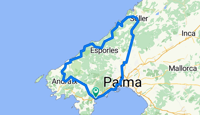
Palmanova-andratx-soller
A cycling route starting in Magaluf, Balearic Islands, Spain.
Overview
About this route
122 km næsten 2200 højde meter det bliver hårdt
- -:--
- Duration
- 122.8 km
- Distance
- 1,489 m
- Ascent
- 1,490 m
- Descent
- ---
- Avg. speed
- 490 m
- Max. altitude
Route quality
Waytypes & surfaces along the route
Waytypes
Road
72.6 km
(59 %)
Cycleway
23.1 km
(19 %)
Surfaces
Paved
111.1 km
(90 %)
Asphalt
103.2 km
(84 %)
Concrete
7.3 km
(6 %)
Continue with Bikemap
Use, edit, or download this cycling route
You would like to ride Palmanova-andratx-soller or customize it for your own trip? Here is what you can do with this Bikemap route:
Free features
- Save this route as favorite or in collections
- Copy & plan your own version of this route
- Split it into stages to create a multi-day tour
- Sync your route with Garmin or Wahoo
Premium features
Free trial for 3 days, or one-time payment. More about Bikemap Premium.
- Navigate this route on iOS & Android
- Export a GPX / KML file of this route
- Create your custom printout (try it for free)
- Download this route for offline navigation
Discover more Premium features.
Get Bikemap PremiumFrom our community
Other popular routes starting in Magaluf
 Mallorca a peu: ponent de la badia de Palma (1)
- Distance
- 8.7 km
- Ascent
- 146 m
- Descent
- 146 m
- Location
- Magaluf, Balearic Islands, Spain
 Mallorca: sa Porrassa-cales de ponent de la badia de Palma-cap de cala Figuera-cala Refaubetx-el Toro-sa Porrassa
- Distance
- 32.4 km
- Ascent
- 379 m
- Descent
- 376 m
- Location
- Magaluf, Balearic Islands, Spain
 Son Caliu- Banyalbufar
- Distance
- 74.6 km
- Ascent
- 1,051 m
- Descent
- 1,052 m
- Location
- Magaluf, Balearic Islands, Spain
 Mallorca: Magalug-far de cala Figuera-el Toro-Santa Ponça-Magaluf
- Distance
- 30.6 km
- Ascent
- 386 m
- Descent
- 387 m
- Location
- Magaluf, Balearic Islands, Spain
 Senses Hotels Palmanova - Coll de sa Creu - Galilea
- Distance
- 63 km
- Ascent
- 1,021 m
- Descent
- 1,021 m
- Location
- Magaluf, Balearic Islands, Spain
 Palmanova - Galilea - Valldemossa - Sóller - Coll de Sóller - Esporles - Galilea - Palmanova
- Distance
- 126.2 km
- Ascent
- 1,735 m
- Descent
- 1,735 m
- Location
- Magaluf, Balearic Islands, Spain
 Mallorca: Magaluf-cap de cala Figuera-el Toro-Santa Ponça-Magaluf
- Distance
- 31.4 km
- Ascent
- 233 m
- Descent
- 233 m
- Location
- Magaluf, Balearic Islands, Spain
 Hotel Son Caliu Oasis Spa 4* - Sant Elm - Coll de n´Esteva
- Distance
- 59.4 km
- Ascent
- 751 m
- Descent
- 753 m
- Location
- Magaluf, Balearic Islands, Spain
Open it in the app